Marine Biodiversity Science Center
Sea-level rise refers to the long-term increase in the average height of the ocean’s surface relative to the land. Over the past century, global sea levels have climbed approximately eight to nine inches, with the rate of rise accelerating in recent decades. This phenomenon occurs when warming ocean waters expand and when land-based ice from glaciers and polar ice sheets melts into the sea. Understanding this definition matters because sea-level rise represents one of the most measurable and consequential effects of our changing climate, directly threatening coastal ecosystems, marine biodiversity, and hundreds of millions of people living near shorelines.
The science behind sea-level rise combines physics, oceanography, and climate science. Thermal expansion accounts for roughly half of observed sea-level rise since the mid-20th century. As ocean temperatures increase by even fractions of a degree, water molecules spread apart slightly, causing the total volume to grow. The remaining contribution comes from melting ice, particularly from Greenland and Antarctic ice sheets that hold enough frozen water to raise global sea levels by more than 200 feet if completely melted. Mountain glaciers worldwide also contribute measurably to rising seas as they retreat under warming conditions.
What makes sea-level rise particularly complex is its uneven distribution across the planet. Coastal regions experience vastly different rates of change due to ocean currents, gravitational effects from ice loss, and geological factors like land subsidence or uplift. Some areas face sea-level rise rates two to three times higher than the global average, while others see minimal change or even slight decreases. These regional variations determine which communities face immediate flooding threats and which marine ecosystems encounter the most dramatic habitat transformations.
For marine conservationists and coastal communities alike, grasping the mechanics and implications of sea-level rise provides essential context for protecting vulnerable species, preserving critical habitats, and building resilience against an uncertain future.
What Is Sea-Level Rise? The Science Behind Rising Oceans
The Two Main Drivers: Thermal Expansion and Ice Melt
Sea-level rise is driven by two primary mechanisms, both intrinsically linked to our warming planet. Understanding these drivers helps us grasp why our oceans are rising and what we can expect in the future.
The first major contributor is thermal expansion. This scientific term describes a simple physical principle: water expands as it warms. Think of heating a pot of water on your stove. As the temperature rises, the water molecules move more vigorously and require more space, causing the overall volume to increase. Now imagine this happening across the vast expanse of our oceans. Even a slight temperature increase translates to significant volume changes when applied to the billions of gallons in our seas. Currently, thermal expansion accounts for approximately one-third to one-half of observed sea-level rise, depending on the region and time period examined.
The second driver is ice melt, which adds fresh water directly to the ocean. Picture filling a glass with ice cubes and water to the brim. As those ice cubes melt, the glass overflows. Similarly, when glaciers in mountain ranges and massive ice sheets in Greenland and Antarctica melt, they transfer water that was previously stored on land into the ocean basins. This contribution has been accelerating in recent decades, with Greenland alone losing an average of 280 billion tons of ice annually.
Dr. Sarah Chen, a glaciologist who has spent fifteen field seasons in Antarctica, shares a striking observation: “Standing on ice sheets that have existed for millennia, knowing they’re disappearing within our lifetime, fundamentally changes how you view our responsibility to future generations.” Her work monitoring ice loss directly informs sea-level projections that coastal communities worldwide depend upon for planning and adaptation.
How We Measure Sea-Level Change
Understanding how sea levels change requires sophisticated monitoring systems that track minute variations across our planet’s oceans. Scientists rely on three primary measurement methods, each offering unique insights into this global phenomenon.
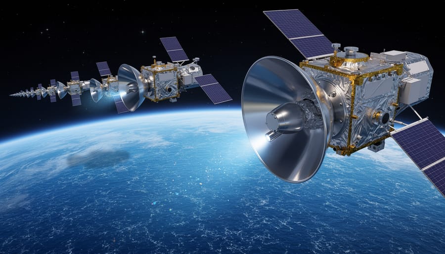
Satellite altimetry has revolutionized sea-level monitoring since the early 1990s. These orbiting instruments use radar pulses to measure ocean surface height with remarkable precision—detecting changes as small as a few millimeters. Satellites provide comprehensive global coverage, capturing data from remote ocean regions that were previously impossible to monitor consistently.
Tide gauges represent our oldest measurement tool, with some stations maintaining continuous records for over a century. These coastal instruments measure water levels relative to nearby land, creating invaluable long-term datasets. By comparing historical tide gauge records with modern satellite observations, scientists can identify acceleration patterns in sea-level rise and account for regional variations.
Dr. Elena Martinez, a marine scientist with fifteen years monitoring Pacific tide stations, shares her perspective: “Every morning, I download data from our network of gauges scattered across dozens of islands. These aren’t just numbers—they represent real communities watching their shorelines change. I’ve worked alongside local volunteers who help maintain these stations, people who understand their observations contribute to a global picture of ocean health. Their dedication reminds me why precision matters. When we detect a two-millimeter annual increase at a remote atoll, we’re documenting evidence that helps coastal communities worldwide prepare for tomorrow.”
Together, these measurement approaches create a comprehensive understanding of sea-level dynamics, enabling scientists to track changes and predict future trends with increasing accuracy.
Not All Coastlines Experience the Same Rise
Local Factors That Amplify or Reduce Impact
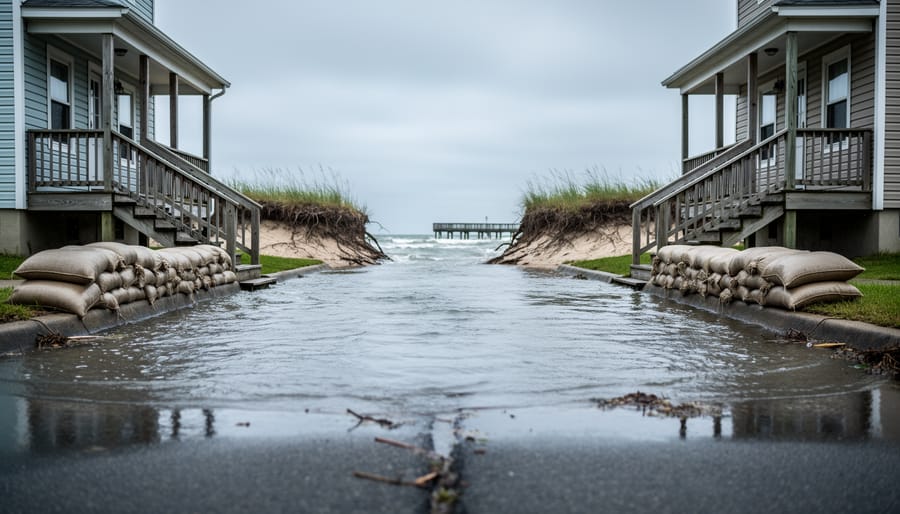
While global sea-level rise provides important baseline data, what coastal communities actually experience can differ dramatically based on local conditions. This is where the concept of relative sea-level rise becomes crucial—the combination of global ocean rise and local land movements that determines whether your shoreline is advancing or retreating.
Land subsidence, the gradual sinking of the ground surface, can dramatically accelerate coastal flooding even when ocean levels remain stable. Many coastal cities sit on sedimentary deposits that naturally compact over time, particularly river deltas built from layers of sand, silt, and clay. Jakarta, Indonesia, for example, experiences some areas sinking up to 25 centimeters annually—far outpacing global sea-level rise. Similarly, parts of the Mississippi River Delta sink several millimeters each year as sediments compact and underground fluids are extracted.
Human activities often intensify this sinking. Groundwater extraction for agriculture and drinking water removes fluids that previously supported overlying sediments, causing them to compress. Oil and gas extraction produces similar effects. Marine biologist Dr. Sarah Chen, who studies coastal wetlands in Louisiana, explains: “We’re essentially pulling the rug out from under these ecosystems. The land sinks while the sea rises—a double threat that makes adaptation exponentially harder.”
Conversely, some regions experience land uplift from tectonic activity or post-glacial rebound, where land previously compressed by ice sheets slowly rises. Parts of Scandinavia actually see relative sea levels falling despite global ocean rise, demonstrating how dramatically local geology shapes coastal futures.
The Marine Ecosystem Consequences
Coastal Wetlands, Mangroves, and Salt Marshes Under Pressure
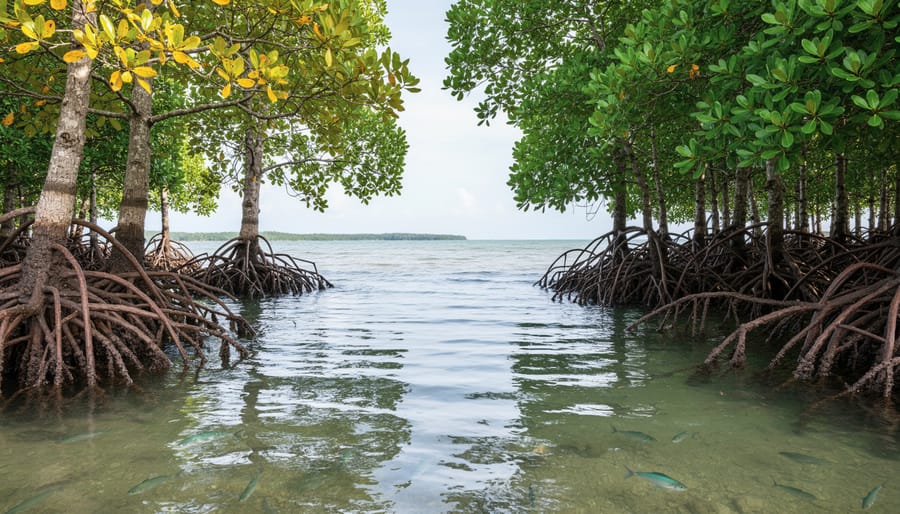
Coastal wetlands, mangroves, and salt marshes face an existential threat from sea-level rise, caught in what scientists call “coastal squeeze.” As ocean waters push inland, these vital ecosystems simultaneously encounter barriers from roads, seawalls, and urban development that prevent their natural migration to higher ground. This pincer effect is devastating nursery habitats that countless fish species depend on during their vulnerable early life stages.
Mangrove forests, which stabilize coastlines and filter pollutants while providing shelter for juvenile fish, are particularly vulnerable. When sea levels rise too rapidly, mangroves cannot establish themselves on higher ground fast enough, especially where human infrastructure blocks their retreat. Salt marshes face similar challenges, drowning under increasing water depths that exceed their ability to build elevation through sediment accumulation.
The consequences ripple throughout marine food webs. Species like snapper, grouper, and shrimp rely on these protected coastal zones for survival during their first months of life. Dr. Maria Santos, a marine biologist studying Florida’s mangrove systems, shares a concerning observation: “We’re seeing nursery grounds shrink by three to five percent annually in some areas. The young fish literally have nowhere to hide from predators.”
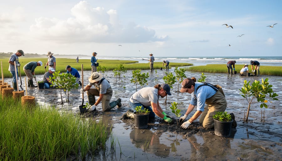
Beyond supporting biodiversity, these ecosystems provide natural coastal protection, absorbing wave energy and preventing erosion. Their loss means communities face both declining fisheries and increased vulnerability to storms. Conservation groups are actively seeking volunteers to participate in coastal habitat monitoring programs and restoration projects, helping scientists track these changes and implement nature-based solutions that give these critical ecosystems room to adapt.
Coral Reefs and Seagrass Beds: Adapting or Drowning?
Coral reefs and seagrass meadows face a challenging paradox as sea levels rise. While you might think rising water would simply give these ecosystems more room to grow upward, the reality is far more complex. These shallow-water habitats depend on precise light conditions to survive, and even modest increases in water depth can dramatically reduce the sunlight reaching them.
Corals, which host photosynthetic algae called zooxanthellae, require abundant sunlight to thrive. As water deepens, turbidity often increases due to coastal erosion and sediment runoff, further blocking vital light. Research shows that many Caribbean coral species struggle when water depth increases beyond their optimal range of 3-15 meters. Some fast-growing coral species like staghorn and elkhorn corals can theoretically grow upward at rates of 10-20 centimeters per year, but current sea-level rise rates, combined with other stressors like warming waters, often exceed their adaptive capacity.
Seagrass beds face similar challenges. These marine flowering plants anchor coastal sediments and provide critical nursery habitat for species like juvenile green sea turtles and conch. Dr. Maria Santos, a marine biologist studying Florida’s seagrass meadows, explains: “We’re seeing entire beds disappear not because they can’t migrate upward, but because increased water depth and turbidity reduce photosynthesis below survival thresholds.”
The good news? Volunteer monitoring programs along coastlines worldwide help scientists track these changes in real-time, providing crucial data that informs conservation strategies and restoration priorities.
When the Ocean Displaces Communities: The Human Cost
Fishing Communities Losing Their Heritage
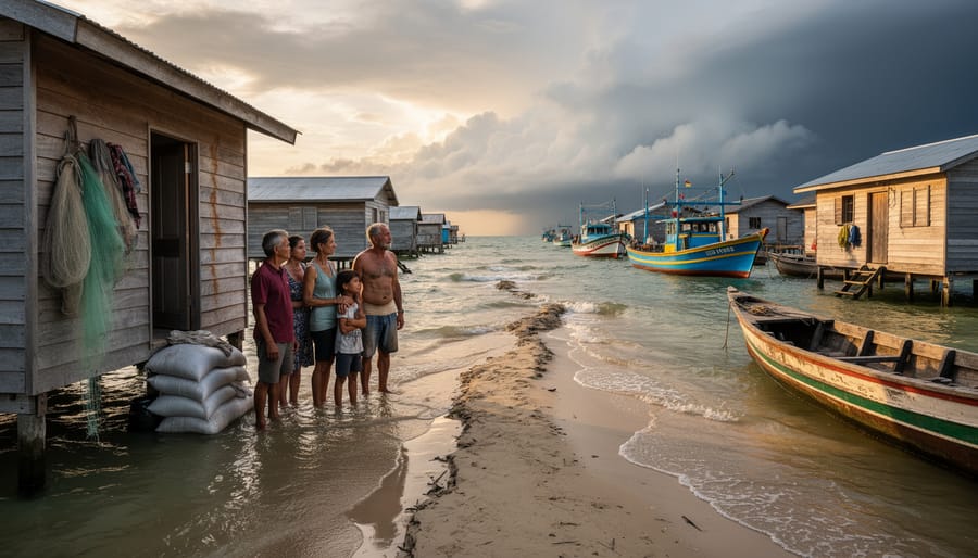
Along the coasts of Vietnam’s Mekong Delta, fisherman Nguyen Van Thanh watches saltwater creep into rice paddies that his family has cultivated for six generations. Rising seas have forced his community to abandon traditional fishing communities grounds as freshwater species disappear and mangrove nurseries vanish beneath advancing tides. “My grandfather could predict fish movements by reading the stars and tides,” he explains. “But the patterns we knew for centuries no longer hold true.”
These personal losses extend far beyond economics. When fishing families relocate inland, they carry with them generations of traditional marine knowledge—understanding of migration patterns, sustainable harvesting techniques, and species behavior that science is only beginning to document. Marine biologist Dr. Sarah Chen, who documents this transition, notes that indigenous fishing communities often possess ecological insights unavailable in scientific literature. “We’re losing living libraries,” she says. “Knowledge about reef health, fish breeding cycles, and ocean current changes passed down through oral tradition.”
The displacement creates a cascading effect. As human communities retreat, their role as ecosystem stewards diminishes. Traditional practices that maintained coastal health disappear alongside the people who practiced them. This erosion of cultural identity parallels the physical displacement of marine species, creating parallel refugee crises—one human, one ecological—both driven by rising waters that redraw ancient boundaries between land and sea.
What We Can Do: Conservation and Adaptation Strategies
Volunteer Opportunities in Coastal Monitoring and Restoration
Community involvement plays a vital role in understanding and responding to sea-level rise. Across coastal regions, numerous ocean conservation groups and research institutions welcome volunteers to participate in monitoring programs and restoration efforts that directly address the impacts of rising seas.
The Marine Biodiversity Science Center offers hands-on opportunities for citizen scientists to assist with coastal monitoring projects. Volunteers help track shoreline changes, measure water levels at monitoring stations, and document coastal erosion patterns. These contributions provide researchers with valuable long-term datasets essential for understanding local sea-level trends.
Habitat restoration programs provide another avenue for meaningful engagement. Volunteers participate in salt marsh restoration, mangrove planting, and seagrass bed rehabilitation—all critical ecosystems that buffer coastal communities from storm surges and provide habitat for marine species displaced by rising waters. Dr. Elena Rodriguez, a marine ecologist who coordinates volunteer programs, shares that many participants develop deep connections to these environments. “Seeing volunteers return season after season, watching the marshes they planted flourish, demonstrates how citizen involvement transforms conservation from abstract concern into personal commitment,” she explains.
Community science projects also engage volunteers in collecting water quality data, surveying marine species distributions, and photographing coastal changes over time. These initiatives not only advance scientific understanding but also build climate-aware communities equipped to advocate for evidence-based coastal management policies.
Sea-level rise, as we’ve explored, is the measurable increase in the average height of the ocean’s surface relative to land—a phenomenon driven by thermal expansion of warming waters and the addition of meltwater from glaciers and ice sheets. This seemingly simple definition carries profound implications that ripple across our planet’s ecosystems and communities. The connection between rising seas and societal displacement isn’t abstract or distant; it’s unfolding now along coastlines worldwide, reshaping marine habitats, eroding cultural heritage sites, and forcing communities to reimagine their futures.
Understanding sea-level rise means recognizing our role in this transformation. The choices we make today about carbon emissions, coastal development, and marine conservation directly influence the pace and severity of these changes. Dr. Sarah Martinez, a marine biologist studying coastal wetland resilience, reminds us that “every fraction of a degree matters, and every restored marsh or protected coral reef strengthens our collective defense against rising waters.”
The good news is that knowledge translates to power when combined with action. Science-based conservation efforts are already demonstrating remarkable success—from mangrove restoration projects that buffer storm surges to community-led initiatives protecting critical coastal habitats. You don’t need a degree in oceanography to contribute. Volunteer opportunities with coastal cleanup organizations, citizen science programs monitoring shoreline changes, and local conservation groups offer meaningful ways to participate.
Our oceans face unprecedented challenges, but they also possess incredible resilience when given the chance to recover. By embracing our collective responsibility—through informed choices, active participation, and unwavering commitment to evidence-based solutions—we can write a different story for our coasts and the communities that depend on them. The time to act is now, and every contribution counts.
jessica
Ava Singh is an environmental writer and marine sustainability advocate with a deep commitment to protecting the world's oceans and coastal communities. With a background in environmental policy and a passion for storytelling, Ava brings complex topics to life through clear, engaging content that educates and empowers readers. At the Marine Biodiversity & Sustainability Learning Center, Ava focuses on sharing impactful stories about community engagement, policy innovations, and conservation strategies. Her writing bridges the gap between science and the public, encouraging people to take part in preserving marine biodiversity. When she’s not writing, Ava collaborates with local initiatives to promote eco-conscious living and sustainable development, ensuring her work makes a difference both on the page and in the real world.