Marine Biodiversity Science Center
Every year, coastlines worldwide lose several feet of land to the relentless forces of waves, currents, and storms. Shoreline erosion—the gradual or sudden wearing away of coastal land—threatens not only beachfront properties and infrastructure but also critical marine habitats that countless species depend on for survival. From nesting sites for sea turtles to feeding grounds for shorebirds, eroding coastlines disrupt entire ecosystems while simultaneously putting human communities at risk.
The acceleration of this natural process poses one of the most pressing challenges in marine conservation today. Rising sea levels, intensifying storm patterns, and human development have transformed erosion from a gradual geological process into an urgent crisis affecting over half of the world’s sandy shorelines. Understanding where, how, and why erosion occurs has become essential for protecting both marine biodiversity and coastal communities.
This is where citizen science emerges as a powerful tool. While professional researchers cannot monitor every stretch of coastline, concerned individuals like you can contribute invaluable data that shapes conservation strategies and informs coastal management decisions. Whether you live near the ocean or visit occasionally, your observations help scientists track erosion patterns, predict future changes, and develop effective intervention methods.
The good news? Participating in shoreline erosion monitoring requires no advanced degree or expensive equipment. Simple techniques like photographing reference points, measuring beach profiles, or recording storm impacts provide scientists with the long-term datasets they desperately need. Your involvement transforms from passive concern into active conservation, joining thousands of volunteers worldwide who serve as the eyes and ears protecting our disappearing shores. Together, we can understand, document, and ultimately address one of the ocean’s most visible threats.
Understanding Shoreline Erosion: More Than Just Moving Sand
The Natural Forces Reshaping Our Coasts
Coastal shorelines exist in constant motion, shaped by powerful natural forces that work tirelessly to reshape our ocean boundaries. Understanding these mechanisms helps us appreciate why erosion monitoring matters so much for marine conservation.
Waves serve as the ocean’s primary sculptors, releasing energy accumulated across vast distances. When waves crash against shorelines, they dislodge sediment particles, carrying them away in what marine biologists call longshore drift. The size and frequency of waves directly influence erosion rates—larger waves during storm seasons can remove beach material that took months to accumulate naturally.
Tides add another layer of complexity to this process. As water levels rise and fall twice daily, different portions of the shoreline experience wave action. During high tides, waves reach further inland, attacking cliff bases and undermining coastal structures. Low tides expose previously submerged areas, allowing different erosion patterns to emerge.
Storms dramatically accelerate these processes. Hurricane-force winds generate massive waves that can transform coastlines overnight. Dr. Maria Santos, a marine biologist who has studied erosion patterns for fifteen years, recalls witnessing a single nor’easter remove three meters of beachfront in just twelve hours. “These events remind us that coastal systems are incredibly dynamic,” she explains. “That’s precisely why citizen monitoring proves so valuable—no research team can be everywhere at once.”
Ocean currents complete the picture by transporting displaced sediment along coastlines or pulling it offshore into deeper waters. Together, these forces create an intricate dance of erosion and deposition, constantly redrawing our coastal maps and making regular observation essential for understanding long-term trends.
When Human Activity Speeds Up the Process
While natural forces have shaped coastlines for millennia, human activities have dramatically accelerated erosion rates in recent decades. Understanding these anthropogenic factors is crucial for developing effective conservation strategies and motivating citizen participation in monitoring efforts.
Climate change impacts represent perhaps the most significant driver of accelerated shoreline erosion today. Rising global temperatures cause thermal expansion of ocean water and melting of polar ice, leading to sea-level rise that directly threatens coastal areas. Higher water levels mean waves reach further inland, attacking previously stable shoreline areas. Additionally, warming oceans fuel more intense storms with greater erosive power, creating a compounding effect on vulnerable coastlines.
Coastal development compounds these challenges significantly. When we construct seawalls, jetties, and other hard structures, we disrupt natural sediment flow patterns. Sand that would normally replenish beaches gets trapped or redirected, leaving downstream areas starved of protective material. Buildings and roads replace natural vegetation whose root systems once held soil in place, making these areas more susceptible to erosion.
Marine biologist Dr. Sarah Chen has witnessed these changes firsthand: “In just fifteen years of monitoring Pacific coastlines, I’ve seen beaches I knew as a child disappear entirely. But here’s the hopeful part—citizen scientists are now helping us track these changes in real-time, providing data that drives policy change.”
Groundwater extraction, deforestation of coastal watersheds, and dredging activities further destabilize shorelines, creating urgent needs for community-based monitoring and restoration efforts.
The Power of Citizen Science in Coastal Conservation
Why Scientists Need Your Eyes on the Ground
Professional monitoring of shoreline erosion faces significant challenges that limit comprehensive coastal coverage. Research teams operate under tight budget constraints, with funding typically allocated to specific study sites rather than continuous coastline monitoring. Dr. Sarah Chen, a coastal geomorphologist with twenty years of field experience, explains the reality: “Our team can monitor perhaps three or four beaches intensively, but thousands of kilometers of coastline remain unobserved between our quarterly surveys.”
The constraints extend beyond finances. Scientific teams simply lack the manpower to document erosion events as they happen. Storm surges, king tides, and dramatic coastal changes often occur overnight or during extreme weather when professional researchers cannot safely access sites. By the time scientists return, critical evidence of erosion processes may have already washed away.
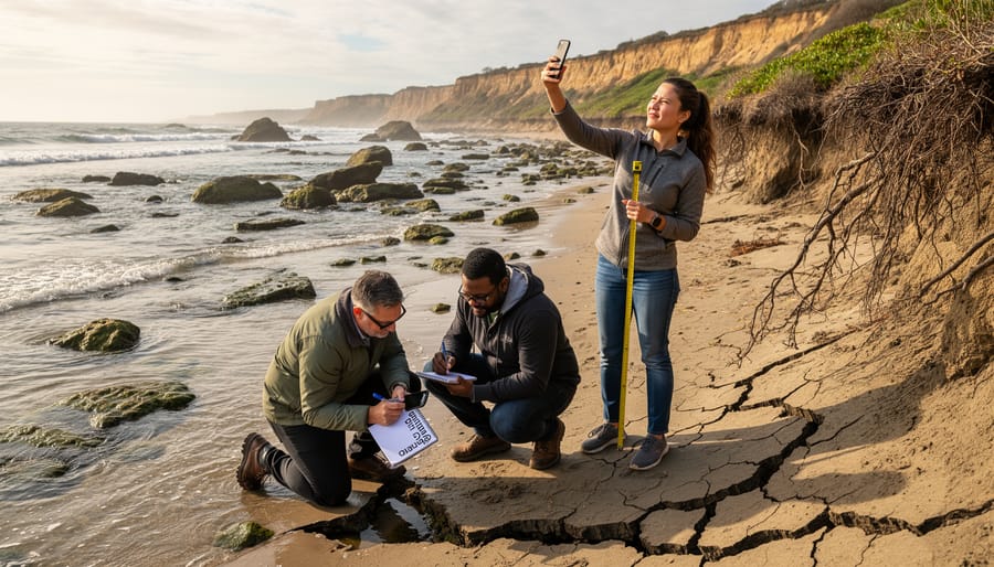
This is where citizen science programs become invaluable. Local residents, beachgoers, and coastal community members provide eyes on the ground across vast geographic areas. Your observations from morning dog walks, weekend beach visits, or daily commutes along coastal roads capture temporal data that professionals miss entirely.
“Citizen scientists give us something we could never afford otherwise: continuous monitoring across diverse locations,” notes Dr. Chen. “When someone photographs the same beach monthly for a year, that dataset becomes scientifically invaluable for understanding seasonal erosion patterns.”
Your regular presence at local shorelines transforms you from casual observer into essential data contributor, filling critical gaps in our understanding of coastal change.
Real Impact: How Citizen Data Changes Outcomes
When citizen scientists document shoreline erosion, their observations create tangible change. In Washington State, years of volunteer-collected erosion data directly influenced the restoration of over 2,000 feet of Puget Sound shoreline. The data revealed critical erosion hotspots affecting salmon habitat, prompting state agencies to prioritize funding for bulkhead removal and beach nourishment projects.
Similarly, coastal communities in Nova Scotia used citizen-collected measurements to successfully advocate for policy changes restricting development in high-erosion zones. Their photographic evidence and measurements, gathered consistently over five years, provided irrefutable proof that protective setback distances needed expansion.
Marine biologist Dr. Sarah Chen shares a powerful example from California: “Volunteers monitoring beach profiles detected accelerated erosion threatening a harbor seal haul-out site. Their quick documentation enabled us to secure emergency funding for protective measures, literally saving a critical breeding ground.”
These successes demonstrate that citizen-gathered data isn’t just valuable for research. It becomes a powerful tool for environmental protection, providing the evidence needed to drive conservation action and inform coastal management decisions that protect both wildlife and communities.
How to Monitor Shoreline Erosion: Tools and Techniques for Everyone
Simple Observation Methods That Make a Difference
You don’t need expensive equipment or advanced training to become an effective shoreline erosion observer. The most powerful monitoring techniques rely on consistency and careful attention to detail rather than sophisticated technology.
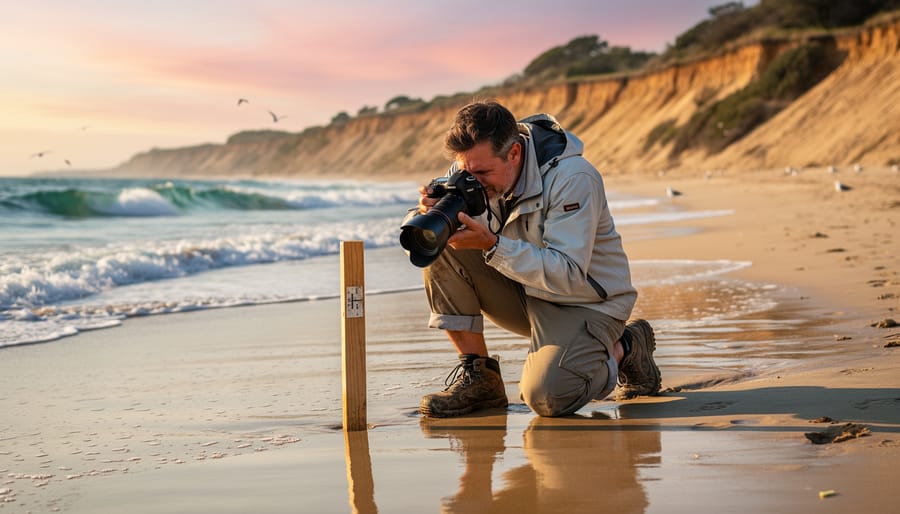
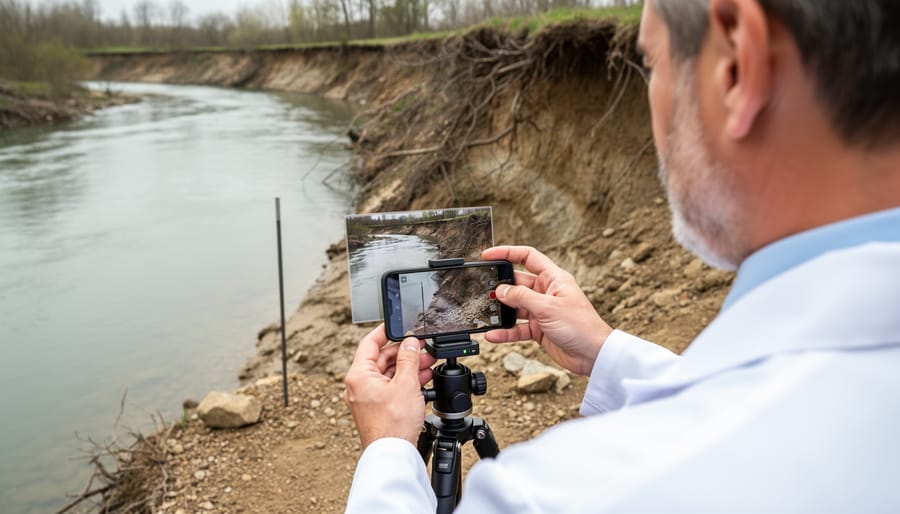
Fixed-point photography stands as the cornerstone of citizen science erosion monitoring. Simply choose a specific location and photograph the same shoreline section from the exact same spot at regular intervals—monthly or after major storms works well. Mark your standing position with a permanent landmark or GPS coordinates. Over time, these photos create an invaluable visual timeline that reveals erosion patterns clearly. Marine biologist Dr. Sarah Chen recalls how a retired teacher’s three-year photo collection of a Massachusetts beach helped her team identify accelerated erosion after a seawall modification, leading to important management changes.
Measuring distances to landmarks provides quantifiable data that complements your photos. Use a measuring tape or smartphone app to record the distance from a fixed point—like a boardwalk post or tree—to the waterline or vegetation edge. Document these measurements during low tide for consistency.
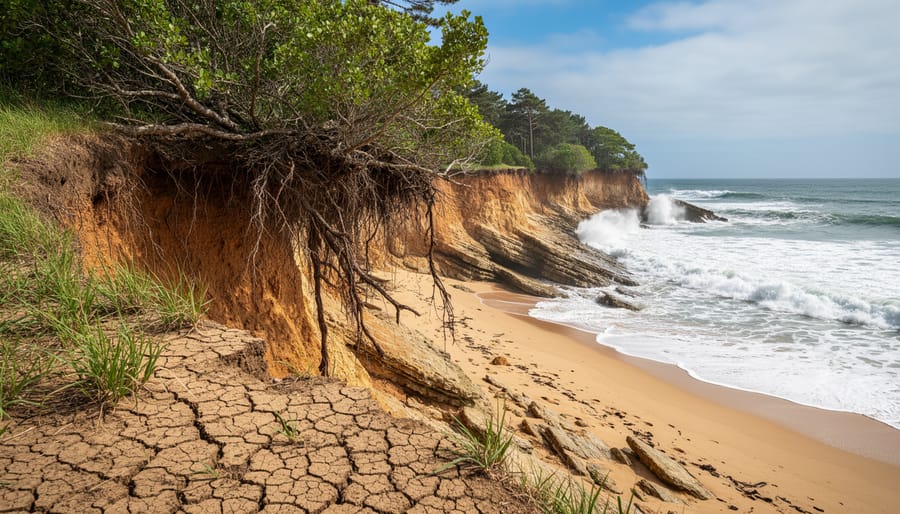
Recording vegetation lines proves especially valuable since plants mark the boundary between stable ground and active erosion zones. Note where beach grasses, shrubs, or trees begin, and watch how this line shifts over time.
Finally, documenting debris patterns tells important stories. Record the high-tide line marked by seaweed, driftwood, or human-made materials. Unusual debris placement often indicates storm surge impacts or changing wave patterns. These simple observations, when shared with research organizations, contribute to our collective understanding of coastal change.
Mobile Apps and Digital Tools for Tracking Change
Technology has transformed how we can contribute to shoreline erosion research, making participation easier and more impactful than ever. Several mobile applications now allow you to become a coastal sentinel, documenting changes wherever you observe them.
The MyCoast app stands out as a powerful tool specifically designed for coastal observation. Available for both iOS and Android, it enables you to photograph shorelines, mark exact GPS locations, and upload your findings directly to regional databases used by researchers and coastal managers. Your observations become part of a larger story about how our coasts are changing.
NOAA’s Crowd Hydrology platform invites you to track water levels and coastal flooding, which directly relate to erosion patterns. The simple interface guides you through submitting photos with measurement markers, creating valuable data points that scientists use to validate models and predict future changes.
For those interested in comprehensive monitoring, the iNaturalist app lets you document not just physical changes but also biological indicators of erosion, such as exposed tree roots or displaced vegetation. These observations help researchers understand the ecological impacts of coastal retreat.
Getting started is straightforward. Download your chosen app, create a profile, and begin documenting during your beach visits. Consistency matters more than frequency—regular observations from the same location provide the most valuable scientific insights. Your smartphone becomes a research instrument, and your curiosity fuels conservation.
What to Record: Essential Data Points
Recording accurate data transforms casual observations into valuable scientific contributions. When monitoring shoreline erosion, consistency in what you document makes your information most useful to researchers and conservationists.
Start by noting the date and exact time of your visit. Erosion patterns shift seasonally and after storm events, so timing provides crucial context. Record the specific location using GPS coordinates or detailed landmarks—precision here allows scientists to track changes at particular sites over months or years.
Weather conditions matter enormously. Document current weather plus recent events: wind direction and speed, recent storms, wave height, and tide stage. These factors directly influence erosion rates and help explain sudden changes.
Capture visible changes in detail. Measure and describe features like cliff retreat, beach width, exposed tree roots, undermined structures, or new sediment deposits. Even seemingly small observations, like changes in vegetation lines or newly exposed rocks, tell part of the story.
Photographs serve as your most powerful tool. Take images from the same position each visit, creating visual timelines that reveal gradual changes invisible day-to-day. Include reference objects for scale and photograph from multiple angles. These images become invaluable records that complement your written observations and contribute to long-term monitoring databases used by researchers worldwide.
Getting Started: Join the Coastal Monitoring Community
Active Programs Looking for Volunteers
Numerous organizations welcome public participation in their volunteer monitoring efforts to track shoreline erosion. The Coastal Observation and Seabird Survey Team (COASST) operates throughout the Pacific Northwest, training volunteers to document beach conditions and erosion patterns alongside seabird populations. Their program provides comprehensive training and data collection protocols that anyone can follow.
The National Oceanic and Atmospheric Administration’s Citizen Science Program coordinates erosion monitoring along U.S. coastlines, partnering with local universities to engage community members in systematic data collection. Volunteers contribute photographs, measurements, and observational data that feed directly into research databases.
The Shore Monitoring Project, run by several marine conservation organizations, focuses specifically on erosion impacts to coastal habitats. Participants receive guidance on identifying erosion features, measuring beach profiles, and documenting changes over time. Many programs offer both in-person and remote participation options, making involvement accessible regardless of your proximity to the coast.
Universities frequently seek volunteers for specific research projects, offering hands-on experience working alongside marine scientists while contributing valuable data to understanding erosion patterns and their ecological consequences.
Starting Your Own Local Monitoring Effort
If your area lacks an established erosion monitoring program, you can become the catalyst for change. Starting your own effort begins with simple, consistent observations. Choose an accessible section of shoreline and visit it regularly—monthly or after major storms—photographing the same landmarks from identical positions. Document changes with measurements, noting beach width, cliff height, or the position of vegetation lines.
Connect with local environmental organizations, university marine science departments, or coastal management offices who may provide guidance, training, or equipment. Many communities have conservation groups eager to support new initiatives. Consider reaching out to established citizen science platforms for protocols and data-sharing opportunities.
Marine biologist Dr. Sarah Chen recalls: “Our most successful monitoring site started with one dedicated teacher and three students. Within a year, they’d engaged the entire coastal community.”
Recruit neighbors, students, or fellow beach enthusiasts to share the workload and expand coverage. Even small-scale efforts contribute valuable localized data that professional researchers often cannot obtain. Document your methods carefully and share findings with local authorities—your observations could inform crucial coastal management decisions. Remember, every major monitoring program began with one person noticing change and deciding to track it systematically.
One Volunteer’s Journey: Making Waves Through Observation
Marine biologist Dr. Sarah Chen’s journey into shoreline erosion monitoring began with a simple walk along her local beach five years ago. “I noticed the dunes had receded dramatically from where I remembered them as a child,” she recalls. What started as curiosity transformed into dedicated monthly monitoring at three coastal sites.
Through systematic observations and photographs, Sarah documented a 15-foot shoreline retreat over three years, data that proved instrumental in securing protective dune restoration funding. “The most rewarding moment came when local officials used my observations in their coastal management plan,” she shares. Beyond the numbers, Sarah discovered unexpected connections between erosion patterns and nearshore marine habitats, observing how sediment changes affected local fish populations.
Her advice to aspiring citizen scientists? “Start simple. Consistency matters more than fancy equipment. Your observations, combined with others, create a powerful picture of coastal change that helps protect these vital ecosystems for future generations.”
The Ripple Effect: How Erosion Monitoring Protects Marine Life
Coastal Habitats at Risk
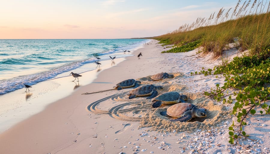
Shoreline erosion poses a direct threat to numerous marine and coastal species that have evolved to depend on stable beach environments. Sea turtles, including loggerheads and green turtles, require undisturbed sandy beaches for nesting. As erosion narrows beaches and alters sand composition, suitable nesting sites disappear, forcing females to nest in suboptimal locations where eggs face higher risks of tidal inundation or predation.
Shorebirds like piping plovers and least terns face similar challenges. These ground-nesting species need wide, flat beaches with minimal disturbance. Erosion reduces available habitat, pushing birds into crowded conditions where competition intensifies and nesting success declines. Dr. Elena Martinez, a marine biologist studying coastal bird populations, shares: “I’ve watched entire nesting colonies relocate three times in five years as their preferred beaches literally washed away.”
Intertidal organisms, including crabs, mollusks, and small fish, depend on the delicate balance between land and sea. Rapid erosion disrupts sediment layers, destroys burrows, and eliminates the stable substrate these creatures need for feeding and reproduction. The cascading effects ripple through the food web, affecting larger predators that rely on these populations.
Understanding these impacts creates urgency for monitoring efforts, and citizen scientists play a vital role in documenting how erosion affects wildlife populations along our coasts.
From Data to Protection
Erosion monitoring data serves as the foundation for targeted conservation strategies that protect vulnerable coastal ecosystems. When researchers and citizen scientists track changes in shoreline structure, they identify critical areas where intervention can make the greatest impact. This information guides decisions about where to implement coastal habitat restoration projects, such as planting native dune grasses or installing living shorelines that stabilize sediments while providing wildlife habitat.
Dr. Sarah Chen, a coastal ecologist working in British Columbia, shares how community-collected data directly influenced protection efforts: “Volunteers documented rapid erosion threatening a crucial seal haul-out site. Within months, we secured funding for natural barriers that reduced wave impact by 40 percent. Those seals now have a stable resting area again.”
The data also helps predict future erosion patterns, allowing conservationists to relocate nesting sites for shorebirds before habitat loss occurs. By connecting measurements to meaningful action, citizen scientists become partners in safeguarding the species that depend on healthy shorelines for survival.
Shoreline erosion stands as one of the most visible indicators of our changing coastlines, and monitoring its progression has never been more critical. The data collected through citizen science initiatives provides researchers and policymakers with invaluable information to protect vulnerable coastal ecosystems and the communities that depend on them.
The remarkable truth is that meaningful conservation doesn’t require an advanced degree or specialized equipment. As Dr. Maria Santos, a coastal geologist who has worked with hundreds of volunteers, often shares: “Some of our most valuable erosion data comes from community members who simply show up consistently with a camera and measuring tape. Their dedication transforms them into essential partners in marine conservation.”
Every measurement recorded, every photograph taken, and every observation logged contributes to a growing body of knowledge that shapes our understanding of coastal change. When thousands of individuals commit to monitoring their local shorelines, the collective impact becomes transformative. This collaborative effort creates comprehensive datasets that no single research institution could achieve alone.
The invitation to join this important work is open to everyone. Whether you can dedicate an hour monthly or become a regular observer, your participation matters. Connect with local environmental organizations, download monitoring apps, or reach out to marine research centers to find opportunities near you.
Your observations today will help protect coastal habitats for generations to come. The shoreline needs its champions, and that champion can be you.
jessica
Ava Singh is an environmental writer and marine sustainability advocate with a deep commitment to protecting the world's oceans and coastal communities. With a background in environmental policy and a passion for storytelling, Ava brings complex topics to life through clear, engaging content that educates and empowers readers. At the Marine Biodiversity & Sustainability Learning Center, Ava focuses on sharing impactful stories about community engagement, policy innovations, and conservation strategies. Her writing bridges the gap between science and the public, encouraging people to take part in preserving marine biodiversity. When she’s not writing, Ava collaborates with local initiatives to promote eco-conscious living and sustainable development, ensuring her work makes a difference both on the page and in the real world.