Marine Biodiversity Science Center
Marine biomes cover over 70% of Earth’s surface, yet standardized methods for classifying and studying these vast ecosystems have only recently enabled scientists to capture their true complexity. Understanding the major categories—from sunlit coral reefs to the mysterious depths of the abyssal zone—requires both ecological knowledge and consistent data collection practices that allow researchers worldwide to compare findings and tracking species across different ocean regions.
The challenge facing marine scientists today extends beyond simply identifying where one biome ends and another begins. Each marine environment, whether coastal estuaries or open ocean waters, hosts unique communities of organisms adapted to specific conditions like temperature, salinity, light availability, and pressure. However, without standardized classification systems and data protocols, comparing biodiversity between a kelp forest off California’s coast and seagrass meadows in the Mediterranean becomes nearly impossible.
Recent advances in marine biodiversity databases have transformed how we document these ecosystems. When researchers in Australia record species observations using the same data standards as teams working in the Arctic Ocean, the global scientific community gains unprecedented insights into distribution patterns, migration routes, and ecosystem health indicators. This collaborative approach has revealed surprising connections between seemingly distant marine environments and helped identify critical habitats requiring immediate conservation attention.
For students beginning their journey into marine science, understanding these biome classifications provides essential context for grasping larger concepts like ocean circulation, climate regulation, and food web dynamics. For conservation professionals, recognizing the distinct characteristics of each biome informs protection strategies tailored to specific environmental conditions. Whether you’re planning to volunteer with coastal cleanup initiatives or pursuing advanced marine research, knowing how scientists categorize and study ocean environments empowers more effective conservation action.
Understanding Marine Biomes Through the Lens of Data Standards
What Makes a Marine Biome Distinct?
Marine biomes stand apart from their terrestrial counterparts through several measurable physical and chemical characteristics that create distinct underwater worlds. Understanding these parameters is essential for researchers working to document and protect ocean biodiversity.
Depth serves as perhaps the most defining feature, determining whether sunlight can penetrate to support photosynthetic life. The ocean’s vertical zones range from sun-drenched surface waters down to the pitch-black abyssal plains thousands of meters below. Light penetration typically extends only to about 200 meters, creating what scientists call the photic zone where marine plants and algae thrive.
Temperature varies dramatically across marine environments, from frigid polar waters hovering near freezing to tropical seas exceeding 30 degrees Celsius. These temperature gradients influence which species can survive in different regions and affect ocean circulation patterns that distribute nutrients worldwide.
Salinity, or salt concentration, adds another layer of complexity. While most ocean water maintains approximately 35 parts per thousand salinity, coastal areas influenced by freshwater river input can show much lower levels, creating unique brackish environments that support specialized communities.
Recording these parameters consistently has revolutionized marine research. Standardized databases now allow scientists worldwide to share oceanographic measurements using agreed-upon formats and units. When Dr. Sarah Chen, a marine biologist studying coral reef resilience, collects temperature data in Indonesia, she can directly compare her findings with historical records from the Caribbean because both datasets follow the same protocols. This standardization enables large-scale analysis of climate change impacts and helps identify priority areas for conservation action, making every measurement count toward protecting our ocean’s future.
The Cost of Inconsistent Data
In 2012, a multi-national effort to establish marine protected areas in the Coral Triangle faced unexpected setbacks due to inconsistent biome classification. Research teams from different countries had collected valuable data on reef ecosystems, but their varying definitions of what constituted a “coral reef biome” versus “coastal transitional zones” created a confusing patchwork of information. One team classified shallow seagrass beds adjacent to reefs as separate entities, while another included them within the reef biome boundaries.
Dr. Maria Santos, a marine biologist who worked on harmonizing the datasets, recalls the frustration: “We had five years of biodiversity surveys that we couldn’t properly compare. Critical decisions about protection boundaries were delayed by eighteen months while we reconciled the classifications.”
The consequences extended beyond paperwork. Migratory species moving between interconnected habitats fell through gaps in protection plans because datasets didn’t align on ecosystem boundaries. This real-world example demonstrates why standardized classification systems matter profoundly for conservation success.
Today, initiatives promoting unified marine biome standards help prevent such complications. When researchers worldwide use consistent terminology and classification criteria, conservation efforts can move forward efficiently, protecting the biodiversity that depends on our collective action and coordinated understanding of ocean ecosystems.
Coastal and Intertidal Biomes: Where Land Meets Sea
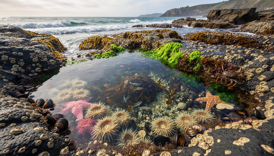
Rocky Intertidal Zones
The rocky intertidal zones of the Pacific Northwest showcase one of the most dynamic marine biomes, where crashing waves meet stubborn shorelines. This habitat serves as a living laboratory for understanding how standardized data collection transforms our knowledge of marine ecosystems.
Researchers studying these shores employ systematic monitoring protocols that divide the zone into distinct bands: splash, high, middle, and low intertidal. Each band hosts unique communities adapted to varying degrees of exposure. By using standardized habitat descriptors like substrate type, slope angle, and wave exposure levels, scientists can compare data across hundreds of sites from California to Alaska.
Key species surveys focus on indicator organisms such as ochre sea stars, California mussels, and barnacle populations. Volunteers participating in programs like the Multi-Agency Rocky Intertidal Network (MARINe) receive training to identify these species and record their abundance using quadrat sampling—a standardized method involving one-square-meter frames placed at predetermined locations.
Marine biologist Dr. Sarah Chen recalls her first volunteer survey: “Learning to distinguish different barnacle species while waves soaked my field notebook taught me that good data requires both precision and persistence.”
These consistent methodologies allow researchers to track long-term changes, from sea star wasting disease impacts to climate-driven range shifts. The standardized approach means a student collecting data in Oregon contributes to the same dataset as professional scientists in British Columbia, creating powerful collaborative insights into ecosystem health.
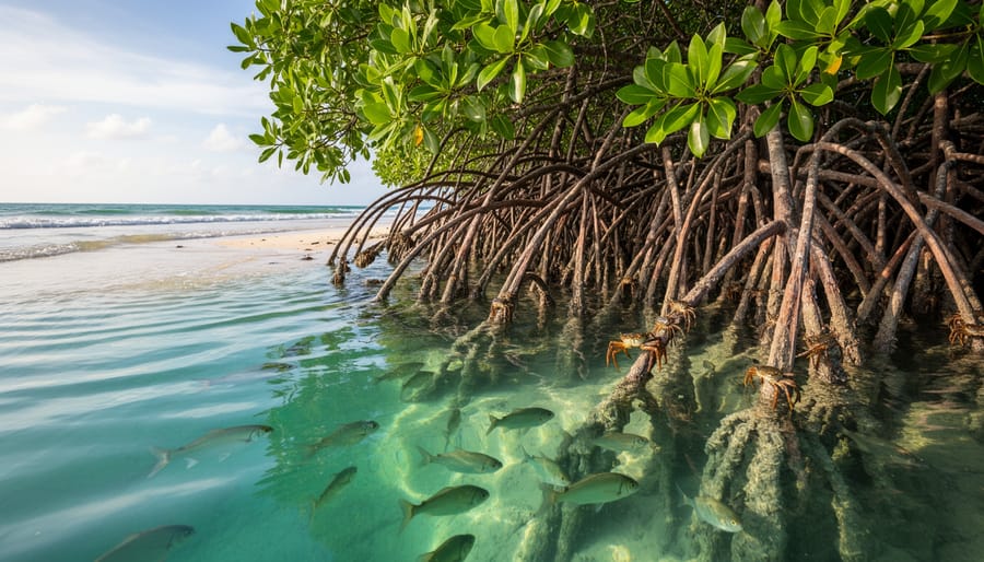
Mangrove Ecosystems
Mangrove ecosystems represent one of the ocean’s most productive biomes, thriving where saltwater meets land in tropical and subtropical regions. Florida’s mangrove forests and the extensive systems throughout Southeast Asia demonstrate how these unique environments function as vital carbon sinks while supporting extraordinary biodiversity.
In Florida’s Everglades, red, black, and white mangroves create intricate root systems that shelter juvenile fish, manatees, and over 200 bird species. Meanwhile, Southeast Asia’s mangrove forests, the world’s most extensive, support Bengal tigers, proboscis monkeys, and countless marine species. These ecosystems store up to four times more carbon per hectare than terrestrial forests, making them critical allies in climate regulation.
Standardized data collection across these regions has revolutionized our understanding of mangrove health and biodiversity. Dr. Maria Santos, a marine ecologist working in the Philippines, shares that consistent monitoring protocols now allow scientists to compare species abundance, water quality, and carbon storage rates between Florida and Asian mangroves. This data supports coastal restoration efforts worldwide.
Volunteers can participate in mangrove monitoring through organizations like Earthwatch, helping collect standardized data on seedling growth and wildlife populations. These citizen science contributions directly inform conservation strategies, proving that protecting mangroves requires both scientific rigor and community engagement across continents.
Seagrass Meadows
Seagrass meadows in the Mediterranean and Caribbean create underwater prairies that shelter countless marine species, from juvenile fish to endangered sea turtles. These vital habitats face threats from coastal development and climate change, making standardized monitoring essential for their protection. Scientists use consistent data protocols to track seagrass health, measuring factors like shoot density, leaf length, and species composition at regular intervals. The SeagrassNet global monitoring program, which welcomes trained volunteers, demonstrates how standardized data collection across sites enables researchers to identify trends and respond to declining meadow health.
In the Caribbean, citizen scientists work alongside marine biologists to document species diversity within seagrass beds, recording everything from tiny seahorses to grazing manatees. Dr. Maria Santos, a marine ecologist in the Florida Keys, shares how volunteers help collect water quality data and photograph quadrat samples, creating valuable datasets that inform conservation decisions. These standardized observations reveal how seagrass meadows function as carbon sinks and nursery grounds, supporting fisheries and coastal communities. By participating in monitoring programs or supporting seagrass restoration projects, anyone can contribute to protecting these remarkable ecosystems.
Open Ocean Biomes: Standardizing the Vast Blue
Epipelagic Zone (Sunlight Zone)
The epipelagic zone extends from the ocean’s surface down to approximately 200 meters, where sunlight penetrates sufficiently to support photosynthesis. This productive layer hosts remarkably diverse ecosystems, from the coral-rich waters of Indonesia’s Coral Triangle to the kelp forests along California’s temperate coastline.
Satellite remote sensing has revolutionized how scientists monitor this zone, measuring chlorophyll concentrations and sea surface temperatures across vast ocean expanses. Marine biologist Dr. Elena Torres recalls her first research expedition combining satellite imagery with ship-based water sampling: “We could finally see patterns we’d only theorized about. Standardizing our measurements with other research teams meant our tropical Pacific data could be directly compared with Arctic studies.”
Modern data standardization protocols ensure that observations collected from research vessels, autonomous floats, and remote sensors follow consistent formats. When researchers in the Great Barrier Reef measure plankton density using the same methodologies as teams monitoring temperate Atlantic waters, conservation efforts become more coordinated and effective.
Citizen scientists contribute meaningfully to epipelagic zone monitoring through programs like Secchi disk depth measurements, which track water clarity worldwide. These standardized observations, collected by thousands of volunteers aboard sailboats and fishing vessels, provide invaluable data complementing sophisticated satellite systems and helping scientists understand how climate change affects our ocean’s sunlit surface waters.
Mesopelagic and Deeper Waters
Below 200 meters, sunlight fades into the twilight zone (mesopelagic), where bioluminescent organisms create their own light to hunt and communicate. Deeper still, the midnight zone (bathypelagic) remains in perpetual darkness, hosting creatures like anglerfish with luminous lures and giant squid with eyes the size of dinner plates. These deep-sea residents have evolved remarkable adaptations: slow metabolisms to conserve energy, specialized pressure-resistant proteins, and enhanced sensory organs to navigate the darkness.
Studying these extreme environments presents unique challenges. Submersibles and remotely operated vehicles (ROVs) capture glimpses of life at crushing depths, but these expeditions are costly and limited. Dr. Maria Chen, a deep-sea biologist, shares: “Every dive reveals species we’ve never seen before. Standardizing how we document these discoveries ensures future researchers can build on our work.”
Standardized data collection methods become especially critical here, where access is restricted. Environmental DNA sampling offers a less invasive alternative, detecting species from water samples without direct observation. Volunteer programs now support deep-sea research through citizen science initiatives that help analyze footage and classify organisms, making deep-ocean exploration more collaborative and accessible to ocean enthusiasts worldwide.
Upwelling Zones
Upwelling zones represent some of Earth’s most productive marine environments, where deep, nutrient-rich waters rise to the surface, creating biological hotspots. The California Current along North America’s west coast and the Peru Current off South America exemplify these dynamic systems, supporting massive fisheries and diverse marine life from sardines to sea lions.
Standardized oceanographic data has revolutionized our understanding of these zones. By using consistent measurements for nutrient concentrations, chlorophyll levels, and water temperature, scientists can now compare productivity patterns across distant upwelling systems. This data reveals that while upwelling zones occupy less than 1% of the ocean’s surface, they produce nearly 20% of global fish catches.
Marine biologist Dr. Elena Rodriguez shares her experience: “Working with standardized datasets allowed our team to predict upwelling intensity changes linked to climate patterns. This helps fishing communities prepare for seasonal variations.”
Volunteers can contribute through citizen science programs monitoring coastal water quality in upwelling regions, providing valuable data that complements satellite observations and research vessels, strengthening our collective understanding of these vital ecosystems.
Seafloor Biomes: Mapping the Ocean’s Foundation
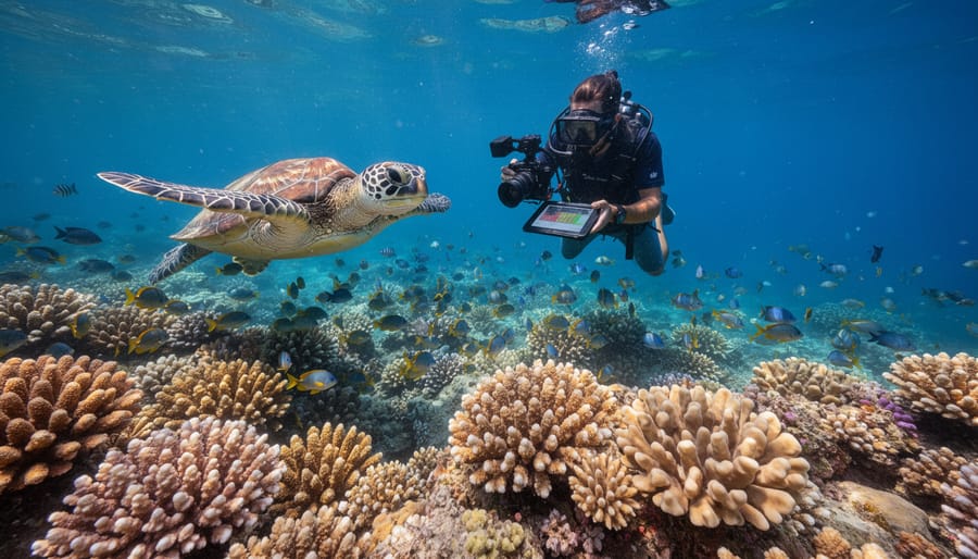
Coral Reef Ecosystems
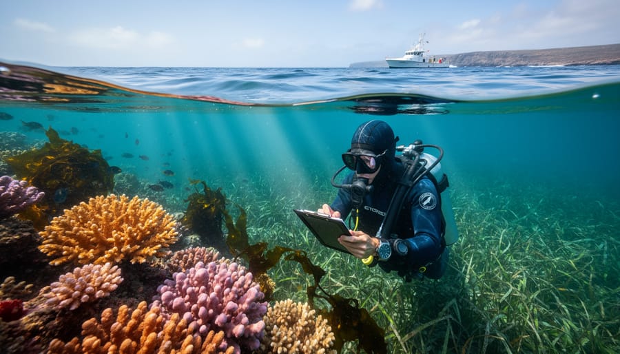
Coral reef ecosystems represent some of the most biodiverse marine biomes on Earth, yet they face unprecedented threats that demand coordinated monitoring efforts. The Great Barrier Reef and Caribbean reefs serve as prime examples of how standardized health monitoring protocols transform conservation practice. Scientists working across these regions now employ consistent metrics to assess coral bleaching severity, using standardized color reference cards and temperature logging systems that allow direct comparisons between distant reef systems.
Modern reef monitoring relies heavily on standardized species inventories that catalog everything from hard corals to reef fish populations. Marine biologist Dr. Sarah Chen recalls her first volunteer expedition to the Caribbean: “We used photo-quadrat sampling methods identical to those employed at the Great Barrier Reef. This consistency meant our data could immediately contribute to global reef health databases.” These standardized approaches enable researchers to track population changes over time and identify early warning signs of ecosystem decline.
Threat assessments now incorporate uniform frameworks measuring ocean acidification, water quality parameters, and physical damage from storms or human activity. Volunteers can participate in reef monitoring programs worldwide, contributing valuable data through citizen science initiatives that follow these established protocols. This collaborative approach demonstrates how standardized data collection empowers communities to protect these vital ecosystems while advancing scientific understanding.
Deep-Sea Hydrothermal Vents
Deep-sea hydrothermal vents represent one of Earth’s most extreme marine biomes, where superheated mineral-rich water erupts from the ocean floor, creating oases of life in complete darkness. These remarkable ecosystems, found along mid-ocean ridges in both the Pacific and Atlantic oceans, challenge our understanding of where life can exist.
Standardized data collection at vent sites has revolutionized our knowledge of extremophile communities. Scientists document water temperatures exceeding 400°C at vent openings, pH levels ranging from highly acidic to alkaline, and unique chemical signatures including high concentrations of hydrogen sulfide and methane. These measurements, recorded using consistent protocols, allow researchers to compare communities across ocean basins and track how species adapt to these harsh conditions.
Pacific vents, like those at the East Pacific Rise, host giant tube worms, while Atlantic sites feature different species assemblages, including distinctive shrimp populations. Dr. Maria Santos, a marine biologist studying Atlantic vents, shares: “Standardized sampling methods revealed that despite geographic separation, these ecosystems follow similar ecological principles, with chemosynthetic bacteria forming the foundation of food webs.”
Conservation organizations now offer volunteer opportunities in data analysis, helping catalog newly discovered vent species and supporting protection efforts for these fragile, irreplaceable ecosystems that may hold clues to life’s origins.
Continental Shelves and Slopes
Continental shelves and slopes, extending from coastlines to about 200 meters depth, represent some of our ocean’s most productive and economically vital areas. The North Atlantic shelf exemplifies how standardized data collection transforms fishery management. Here, organizations like the International Council for the Exploration of the Sea compile habitat surveys, fish population counts, and environmental measurements using consistent protocols across multiple countries. This collaborative approach allows scientists to track cod, haddock, and other commercial species while monitoring ecosystem health.
Marine biologist Dr. Sarah Chen recalls her first research cruise mapping benthic habitats: “Seeing how our standardized sampling methods could be compared with decades of historical data was eye-opening. We could actually measure recovery in previously overfished areas.” Today, this data-driven approach guides sustainable fishing quotas and marine protected area placement.
Citizen scientists can contribute too. Programs like reef monitoring initiatives train volunteers to collect standardized observations, expanding our understanding of these critical transition zones between shallow coastal waters and the deep ocean, where biodiversity peaks and human activity intersects most intensely.
Polar Marine Biomes: Cold Water Conservation Data
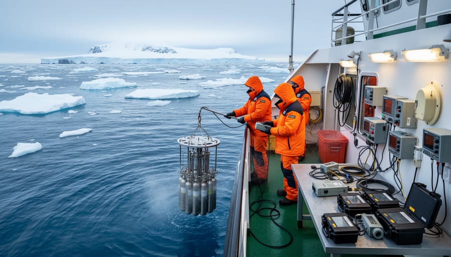
Antarctic Waters
The Southern Ocean encircling Antarctica represents one of Earth’s most pristine marine biomes, harboring extraordinary biodiversity despite frigid temperatures. Antarctic krill form the foundation of this ecosystem, with populations estimated at 379 million tonnes, supporting everything from blue whales to Adélie penguins. These waters host 18 penguin species, along with specialized fish like Antarctic toothfish that produce natural antifreeze proteins.
International collaboration here demonstrates data-sharing at its finest. The Commission for the Conservation of Antarctic Marine Living Resources maintains standardized databases tracking everything from krill biomass to predator populations, enabling researchers worldwide to monitor ecosystem health. Marine biologist Dr. Sarah Chen recalls her first research voyage: “Watching scientists from twelve nations share real-time data on penguin foraging patterns showed me how standardized protocols transcend borders.”
Volunteer opportunities abound through programs like the Antarctic Site Inventory, where citizen scientists help catalog biodiversity. These coordinated efforts, supported by unified data standards, reveal concerning trends like warming waters affecting krill populations, while also celebrating successes in marine protected area establishment. The Antarctic’s story reminds us that effective conservation requires both scientific rigor and international cooperation, with standardized data serving as our common language.
Arctic Marine Ecosystems
The Arctic marine ecosystem stands at the forefront of climate change, making it one of the most critical biomes to monitor and understand. These frigid waters, once locked beneath seasonal and permanent sea ice, are transforming at unprecedented rates. Marine biologists like Dr. Sarah Chen, who has spent fifteen years tracking Arctic cod populations, emphasize how standardized baseline data collection has become essential for documenting these rapid changes. “When we use consistent monitoring protocols across research stations,” she explains, “we can clearly see how declining ice coverage affects everything from phytoplankton blooms to polar bear hunting grounds.”
Scientists rely on standardized oceanographic measurements to track water temperature shifts, salinity changes, and ice thickness variations across the Arctic basin. This uniform data reveals troubling trends: some areas now experience ice-free summers for the first time in recorded history, fundamentally altering food webs that evolved over millennia. Walruses struggle to find resting platforms, while seabirds face shifting prey distributions.
Conservation organizations now offer volunteer opportunities for citizen scientists to help process satellite imagery and contribute to Arctic monitoring databases. By participating in these efforts, anyone can support the crucial work of documenting and protecting this vulnerable ecosystem before irreversible tipping points are reached.
Putting Standards Into Practice: How You Can Contribute
You don’t need a Ph.D. to make meaningful contributions to marine science. Across the globe, citizen scientists are playing a vital role in documenting marine biodiversity using standardized protocols that make their observations as valuable as data collected by professional researchers.
Dr. Elena Rodriguez, a marine ecologist with 15 years of experience, witnessed this firsthand during a community science initiative in California’s kelp forests. “We trained 40 volunteers to identify and document sea star populations using our standardized survey methods,” she recalls. “Within six months, they had covered more survey sites than our small research team could have monitored in two years. The quality of their data was exceptional because everyone followed the same protocols.” This project not only expanded the research scope but also detected early signs of sea star wasting syndrome across a much broader geographic range than anticipated.
Getting involved in marine data collection is more accessible than ever. Programs like Reef Environmental Education Foundation (REEF) train recreational divers to conduct standardized fish surveys during their regular dives. Participants learn to identify species and record abundance data using consistent methods, creating datasets that scientists use to track population trends and ecosystem changes.
For those who prefer staying on land, smartphone apps like iNaturalist allow anyone to contribute marine observations from tide pools and beaches. The key is following simple guidelines: taking clear photographs, recording GPS coordinates, and noting the date and time. These seemingly basic details become powerful when thousands of observations are combined and analyzed.
Students can participate through classroom programs like GLOBE Observer, which includes protocols for monitoring coastal water quality and documenting marine debris. These activities teach scientific methodology while contributing to global databases that inform conservation decisions.
Shore-based monitoring programs also welcome volunteers for regular surveys of shorebirds, marine mammals, and intertidal communities. Organizations typically provide training sessions covering species identification and data recording techniques, ensuring consistency across all participants.
The beauty of standardized citizen science lies in its dual impact: advancing research while fostering ocean stewardship. Every observation counts, and your contribution could be the data point that reveals an important trend or helps protect a threatened species.
From the sunlit coral reefs of the Great Barrier Reef to the mysterious depths of hydrothermal vent communities, these real-world marine biome examples reveal something profound: when scientists across the globe use standardized methods to record what they observe, individual data points become part of something far greater. Each properly classified species observation, each habitat measurement using consistent protocols, contributes to a comprehensive picture of ocean health that transcends geographic boundaries and institutional limitations.
The power of data standardization lies not in abstract theory but in tangible results. When a volunteer diver in Indonesia records a fish species using the same taxonomic standards as a researcher in the Caribbean, their combined data can reveal migration patterns, population trends, and ecosystem connections that neither could detect alone. This consistency transforms scattered observations into actionable intelligence that guides marine protected area designations, informs policy decisions, and tracks the effectiveness of conservation interventions.
As marine biologist Dr. Sarah Chen often reminds her students, “Every standardized observation you contribute becomes part of humanity’s collective understanding of the ocean.” Whether you’re a professional researcher, a citizen scientist participating in reef monitoring programs, or an educator inspiring the next generation of ocean advocates, your engagement matters. The challenges facing marine biomes are significant, but so is our capacity for coordinated action.
The future of ocean conservation depends on accurate, consistent data and the passionate individuals willing to collect it. Your contribution, no matter how small it seems, ripples outward into global impact.
jessica
Ava Singh is an environmental writer and marine sustainability advocate with a deep commitment to protecting the world's oceans and coastal communities. With a background in environmental policy and a passion for storytelling, Ava brings complex topics to life through clear, engaging content that educates and empowers readers. At the Marine Biodiversity & Sustainability Learning Center, Ava focuses on sharing impactful stories about community engagement, policy innovations, and conservation strategies. Her writing bridges the gap between science and the public, encouraging people to take part in preserving marine biodiversity. When she’s not writing, Ava collaborates with local initiatives to promote eco-conscious living and sustainable development, ensuring her work makes a difference both on the page and in the real world.