Marine Biodiversity Science Center

Environmental remote sensing has emerged as a groundbreaking tool in our quest to understand and protect Earth’s ecosystems, revolutionizing ocean monitoring and transforming how we track environmental changes. From satellites orbiting hundreds of miles above Earth to underwater drones mapping coral reefs, this technology enables scientists to collect unprecedented data about our planet’s health without physically disturbing sensitive habitats.
By combining advanced imaging systems, artificial intelligence, and sophisticated sensors, environmental remote sensing provides real-time insights into climate change impacts, biodiversity patterns, and ecosystem dynamics. This technology has become indispensable for tracking deforestation, monitoring ocean temperatures, measuring air quality, and detecting environmental violations across vast geographical areas.
As we face increasing environmental challenges, remote sensing offers a powerful solution for both scientific research and conservation efforts. Its applications range from predicting natural disasters to supporting sustainable resource management, making it an essential tool for environmental scientists, policymakers, and conservation practitioners working to protect our planet’s future.
Cutting-Edge Remote Sensing Technologies in Marine Research
Satellite-Based Systems
Satellite-based remote sensing systems represent a cornerstone of modern environmental monitoring, offering unprecedented capabilities to observe Earth’s ecosystems from space. These systems utilize various types of sensors, including optical, infrared, and radar instruments, to collect data about our planet’s surface and atmosphere.
Modern environmental satellites can capture images with resolutions as fine as 30 centimeters, enabling scientists to monitor even small-scale environmental changes. These platforms collect data across multiple spectral bands, allowing researchers to analyze everything from ocean temperature and chlorophyll concentrations to forest cover and urban development patterns.
Key satellite systems include NASA’s Landsat series, which has provided continuous Earth observation data since 1972, and the European Space Agency’s Sentinel missions, which offer free, open-access environmental monitoring data. These systems are particularly valuable for tracking large-scale environmental phenomena such as deforestation, coral reef health, and climate change impacts.
The advantages of satellite-based systems include their ability to:
– Monitor remote and inaccessible areas
– Provide consistent, long-term data records
– Cover large geographic areas efficiently
– Capture data at regular intervals
– Detect subtle environmental changes over time
Recent technological advances have made satellite data more accessible to researchers and conservation organizations, democratizing access to vital environmental information. This has led to innovative applications in conservation planning, disaster response, and environmental protection efforts worldwide.
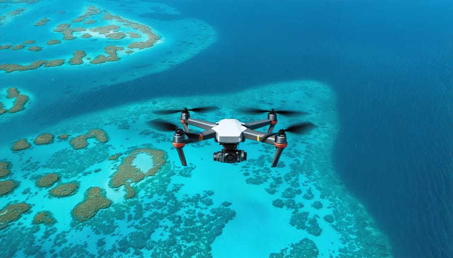
Aerial and Drone Systems
Aerial remote sensing has evolved dramatically with the introduction of unmanned aerial vehicles (UAVs) and sophisticated aircraft systems. These platforms offer unprecedented flexibility and cost-effectiveness for environmental monitoring, combining high-resolution imagery with rapid deployment capabilities.
Traditional aircraft-based systems continue to play a crucial role in large-scale environmental surveys. Fixed-wing aircraft equipped with multispectral sensors and LiDAR systems can cover vast areas efficiently, making them ideal for mapping coastlines, tracking oil spills, and monitoring extensive marine ecosystems. These systems excel at collecting data from altitudes of 1,000 to 10,000 feet, providing broad contextual information about environmental patterns and changes.
Drones have revolutionized local-scale environmental monitoring by offering highly detailed imagery at a fraction of the cost of traditional aerial surveys. Modern UAVs can be equipped with various sensors, including thermal cameras, multispectral imaging systems, and even water sampling devices. Their ability to fly at low altitudes (50-400 feet) enables the capture of extremely detailed data about coral reefs, seagrass beds, and coastal erosion.
The integration of artificial intelligence and automated flight planning has further enhanced these systems’ capabilities. Drones can now follow pre-programmed routes, automatically adjust for weather conditions, and even identify and track marine mammals in real-time. This technology has become invaluable for conservation efforts, allowing researchers to monitor protected areas, track illegal fishing activities, and assess the impact of climate change on coastal ecosystems with unprecedented precision and frequency.
Real-World Applications in Marine Conservation
Tracking Marine Species Movement
Remote sensing technologies have revolutionized our ability to understand and monitor marine life, making tracking marine species migration more efficient and less invasive than ever before. Satellite telemetry, acoustic monitoring, and advanced GPS systems now allow researchers to follow the movements of various marine species across vast ocean distances.
These tracking systems provide crucial data about migration patterns, feeding grounds, and breeding areas of endangered species like whale sharks, sea turtles, and various cetaceans. For instance, researchers recently mapped the complete migration route of blue whales in the Pacific Ocean using satellite tags, revealing previously unknown feeding stops along their journey.
Marine biologists like Dr. Sarah Chen, who has spent a decade studying sea turtle movements, emphasize how this technology has transformed their work. “What once required years of boat-based observations can now be accomplished in months, with far more accurate data,” she explains. This efficiency has led to better-informed conservation strategies and marine protected area designations.
Citizen scientists are also joining the effort through mobile apps that allow them to report marine animal sightings. These observations, when combined with remote sensing data, create a more comprehensive picture of marine species behavior and distribution patterns. The integration of artificial intelligence with tracking systems is now enabling real-time monitoring of marine populations, helping to prevent ship strikes and reducing human-wildlife conflicts.
Coral Reef Health Monitoring
Remote sensing technologies have revolutionized coral reef health monitoring, enabling scientists to track and assess reef conditions across vast oceanic regions with unprecedented efficiency. Satellite imagery and specialized underwater sensors provide real-time data on water temperature, clarity, and coral bleaching events, helping researchers identify threatened areas before visible damage occurs.
Marine biologists like Dr. Sarah Chen have witnessed firsthand how these tools transform conservation efforts. “Using thermal imaging and spectral analysis, we can now detect early signs of stress in coral communities and respond quickly,” she explains. These early warning systems have proven crucial in protecting vulnerable reef systems during mass bleaching events.
Innovative drone technology equipped with hyperspectral cameras captures detailed images of reef structures, allowing scientists to map changes in coral coverage and health over time. This data helps conservation teams prioritize areas for immediate intervention and long-term protection strategies.
Citizen scientists also play a vital role in reef monitoring through programs that combine traditional observation methods with remote sensing data. Volunteers can contribute to global reef health databases by recording local conditions and validating satellite observations, creating a more comprehensive understanding of reef ecosystems.
The integration of artificial intelligence with remote sensing has further enhanced our ability to predict and prevent coral degradation, offering hope for the future of these critical marine habitats.
Ocean Temperature and Climate Change
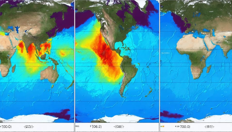
Remote sensing technology has revolutionized our understanding of ocean temperatures and their relationship to climate change. Satellites equipped with advanced thermal sensors continuously monitor sea surface temperatures across the globe, providing scientists with crucial data about warming trends and thermal anomalies.
These measurements reveal concerning patterns in ocean warming, with data showing that oceans absorb more than 90% of excess heat from greenhouse gas emissions. Satellite observations have documented an average increase in sea surface temperature of approximately 0.13°C per decade since 1901, with some regions experiencing even more dramatic changes.
Dr. Sarah Chen, a marine researcher, explains: “Satellite data helps us identify marine heat waves and their impacts on coral reefs and marine ecosystems. This information is vital for conservation efforts and climate adaptation strategies.”
The technology allows scientists to track phenomena like El Niño and La Niña events, which significantly influence global weather patterns. By combining satellite observations with data from ocean buoys and underwater sensors, researchers create comprehensive models of ocean temperature dynamics.
These monitoring systems also help predict potential impacts on marine life, from coral bleaching events to changes in fish migration patterns. The data supports early warning systems for coral reef managers and fishing communities, enabling proactive measures to protect vulnerable marine ecosystems.
Recent innovations in satellite technology have improved measurement accuracy and frequency, providing increasingly detailed insights into ocean temperature variations and their broader implications for global climate systems.
Success Stories from the Field
Saving the Great Barrier Reef
Remote sensing technology has emerged as a crucial tool in protecting Australia’s Great Barrier Reef, one of Earth’s most precious marine ecosystems. Satellite imagery and aerial surveys enable scientists to monitor coral bleaching events, assess reef health, and track recovery patterns across vast stretches of ocean that would be impossible to study through traditional methods alone.
In 2016, when the reef faced a severe bleaching crisis, remote sensing data helped researchers identify the most affected areas and direct immediate conservation efforts where they were needed most. Using thermal imaging and specialized cameras, scientists could map temperature variations and coral stress levels across thousands of square kilometers of reef system.
The CoralWatch program, combining remote sensing with citizen science, has revolutionized reef monitoring. Marine biologists like Dr. Sarah Chen work with local volunteers to ground-truth satellite data, creating a comprehensive picture of reef health. “Remote sensing gives us the big picture,” explains Chen, “while our volunteer divers provide detailed observations that validate what we see from above.”
Recent technological advances have improved the resolution and accuracy of remote sensing tools. Scientists can now detect subtle changes in coral color, an early warning sign of bleaching, and monitor water quality parameters that affect reef health. This data helps conservation managers make informed decisions about protective measures and rehabilitation efforts, contributing to more effective reef preservation strategies.
Tracking Illegal Fishing Activities
Remote sensing technology has emerged as a powerful tool in the fight against illegal fishing, with several notable success stories demonstrating its effectiveness. In 2019, a collaborative effort between Global Fishing Watch and the Indonesian government led to the arrest of multiple vessels engaged in illegal fishing within protected marine areas. Using satellite imagery and automated identification system (AIS) data, authorities tracked suspicious vessel movements and documented illegal activities in real-time.
Another breakthrough came from the Pacific region, where the combination of satellite monitoring and machine learning algorithms helped identify dark vessels – those attempting to evade detection by turning off their tracking systems. This technology enabled Pacific Island nations to protect their exclusive economic zones more effectively, resulting in a 20% reduction in illegal fishing activities between 2018 and 2020.
In the Mediterranean Sea, remote sensing has revolutionized enforcement capabilities. Environmental organizations partnered with local authorities to deploy advanced radar systems and satellite monitoring, successfully intercepting illegal driftnets and protecting endangered marine species. One particularly notable case involved tracking a fleet of vessels operating illegally in marine protected areas, leading to substantial fines and the prevention of unauthorized fishing activities.
These successes have inspired more nations to adopt remote sensing technologies in their maritime surveillance programs, creating a growing network of monitoring systems that make it increasingly difficult for illegal fishing operations to avoid detection.
Future Perspectives and Getting Involved
The future of environmental remote sensing holds tremendous promise for marine conservation and research. Emerging technologies like artificial intelligence and machine learning are revolutionizing how we process and analyze satellite data, making it possible to detect subtle changes in marine ecosystems with unprecedented accuracy. These advances are particularly exciting for marine biodiversity observation networks, which can now monitor vast ocean areas in real-time.
One of the most promising developments is the integration of autonomous underwater vehicles (AUVs) with satellite systems. These robots can dive deeper, stay longer, and collect more detailed data than ever before, while satellites provide the broader context needed to understand ocean-wide patterns. The combination of these technologies creates a more complete picture of marine ecosystem health.
Citizen scientists and marine enthusiasts can now participate in environmental remote sensing projects through various platforms. Many organizations offer training programs where volunteers learn to analyze satellite imagery, track marine species movements, or monitor coral reef health from space. These initiatives not only contribute valuable data but also help build public awareness and support for marine conservation efforts.
Looking ahead, miniaturization of sensing technologies and increased accessibility of satellite data will likely democratize marine research further. Small, affordable sensors that can be deployed by local communities and conservation groups are already in development. These tools will enable more comprehensive monitoring of coastal areas and help communities make informed decisions about resource management.
For those interested in getting involved, numerous opportunities exist. Universities and research institutions regularly seek volunteers for data analysis projects, while conservation organizations offer training in remote sensing techniques. Whether you’re a student, professional, or concerned citizen, there’s a way to contribute to our understanding and protection of marine ecosystems through remote sensing technology.
Environmental remote sensing has revolutionized our ability to monitor, understand, and protect marine ecosystems on an unprecedented scale. From tracking coral reef health to monitoring illegal fishing activities, these technologies provide crucial data that inform conservation strategies and policy decisions. The combination of satellite imagery, underwater sensors, and advanced data analysis enables us to act as stewards of our oceans more effectively than ever before.
However, technology alone cannot save our marine environments. The future of ocean conservation depends on combining these powerful tools with dedicated human effort and community engagement. Whether you’re a citizen scientist contributing to data collection, a student pursuing marine biology, or simply an ocean enthusiast sharing knowledge with others, your role is vital. Together, we can leverage remote sensing technologies to create a sustainable future for our oceans, protecting marine biodiversity for generations to come.
Join us in this crucial mission by supporting marine conservation initiatives, participating in citizen science projects, or pursuing education in environmental remote sensing. The time to act is now.
jessica
Ava Singh is an environmental writer and marine sustainability advocate with a deep commitment to protecting the world's oceans and coastal communities. With a background in environmental policy and a passion for storytelling, Ava brings complex topics to life through clear, engaging content that educates and empowers readers. At the Marine Biodiversity & Sustainability Learning Center, Ava focuses on sharing impactful stories about community engagement, policy innovations, and conservation strategies. Her writing bridges the gap between science and the public, encouraging people to take part in preserving marine biodiversity. When she’s not writing, Ava collaborates with local initiatives to promote eco-conscious living and sustainable development, ensuring her work makes a difference both on the page and in the real world.