Marine Biodiversity Science Center

Beneath the ocean’s surface, a technological revolution is transforming our understanding of marine ecosystems. From autonomous underwater vehicles probing the deepest trenches to satellite-linked buoys monitoring vital signs of our seas, oceanographic technology serves as humanity’s window into the complex world beneath the waves. These innovations have become essential tools for scientists studying everything from climate change impacts to the effectiveness of marine reserves and critical habitats.
Advanced sensors, artificial intelligence, and remote sensing capabilities now enable researchers to collect unprecedented amounts of data about marine life, ocean chemistry, and geological processes. This technological arsenal helps marine scientists track endangered species, map underwater landscapes, and monitor the health of coral reefs with remarkable precision. As climate change and human activities increasingly impact our oceans, these tools provide crucial insights for conservation efforts and policy decisions.
The democratization of marine technology, from affordable underwater drones to citizen science apps, has also opened new possibilities for public participation in ocean research and conservation. This convergence of scientific innovation and accessibility marks a turning point in our ability to understand, protect, and sustainably manage our ocean resources.
Advanced Monitoring Systems: Eyes Beneath the Waves
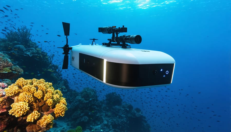
Autonomous Underwater Vehicles (AUVs)
Autonomous Underwater Vehicles (AUVs) have revolutionized marine research by enabling scientists to explore ocean depths previously inaccessible to human divers. These sophisticated underwater drones operate without direct human control, carrying various sensors and imaging equipment to collect vital oceanographic data.
Modern AUVs can navigate independently for weeks or even months, mapping the seafloor, measuring water quality parameters, and documenting marine life in their natural habitat. Their ability to operate in extreme conditions makes them invaluable for studying deep-sea ecosystems and monitoring marine conservation zones.
These vehicles come equipped with advanced features like side-scan sonar, underwater cameras, and chemical sensors. Scientists use them to track marine mammals, study coral reef health, and investigate underwater geological formations. Some AUVs can even collect water samples and small specimens for laboratory analysis.
Recent technological advances have made AUVs more accessible and user-friendly. Smaller, more affordable models are now available for research institutions and conservation organizations. These devices have proven particularly useful in tracking ocean pollution, monitoring fish populations, and studying the impacts of climate change on marine ecosystems.
The data collected by AUVs helps researchers understand ocean dynamics and supports evidence-based conservation strategies. As technology continues to advance, these underwater robots will play an increasingly important role in protecting our oceans for future generations.
Smart Buoys and Environmental Sensors
Smart buoys and environmental sensors represent the frontline of modern ocean monitoring, serving as vigilant sentinels that continuously collect vital data about our marine environments. These sophisticated floating platforms combine multiple sensors to measure everything from water temperature and salinity to wave height and wind speed in real-time.
Advanced sensor networks, such as the ARGO float system, comprise thousands of autonomous devices that drift with ocean currents, periodically diving to depths of 2,000 meters to collect data about ocean conditions. Every 10 days, these floats surface to transmit their findings via satellite to research centers worldwide, providing an unprecedented view of ocean dynamics.
Coastal monitoring stations equipped with smart buoys play a crucial role in early warning systems for tsunamis, harmful algal blooms, and severe weather events. For instance, the NOAA’s National Data Buoy Center maintains a network of over 100 strategically positioned buoys that protect coastal communities and support maritime operations.
Modern environmental sensors can detect minute changes in ocean chemistry, including pH levels, dissolved oxygen, and pollutant concentrations. This capability is particularly valuable for monitoring coral reef health and tracking ocean acidification. Some cutting-edge systems even incorporate artificial intelligence to analyze data patterns and predict environmental changes before they become critical.
Marine scientists and conservationists rely on these technologies to understand ocean health and implement effective protection measures. The data collected helps shape evidence-based policies and supports international conservation efforts.
Satellite Technology and Marine Conservation
Tracking Marine Species
Satellite technology has revolutionized our ability to track and protect marine species across the world’s oceans. By attaching small transmitters to various marine animals, scientists can now monitor their movements in real-time, providing unprecedented insights into migration patterns, feeding grounds, and breeding areas.
For endangered species like sea turtles and whale sharks, satellite tracking has become an invaluable conservation tool. These devices, some no larger than a cell phone, transmit location data whenever the animal surfaces, creating detailed maps of their ocean journeys. Marine biologist Dr. Sarah Chen explains, “We’ve discovered previously unknown migration routes and critical habitats that desperately need protection.”
The technology has also revealed surprising behaviors in marine mammals. Researchers tracked a gray whale’s unprecedented 22,500-kilometer journey from Russia to Mexico, the longest recorded migration of any mammal. This data helps identify shipping routes that may need modification to prevent vessel strikes.
Citizen scientists are increasingly participating in tracking projects through mobile apps and online platforms. When beachgoers spot tagged animals, they can report sightings, contributing to a global database of marine species movements. This collaborative approach has enhanced our understanding of ocean ecosystems while fostering public engagement in marine conservation efforts.
Detecting Illegal Fishing Activities
Satellite technology has revolutionized our ability to monitor and combat illegal fishing operations across the world’s oceans. Advanced systems like Automatic Identification System (AIS) and Vessel Monitoring System (VMS) track ship movements in real-time, creating a digital fingerprint of maritime activity. When vessels suddenly “go dark” by turning off their tracking devices, it often signals potential illegal activities.
Machine learning algorithms now analyze this satellite data to detect suspicious patterns, such as vessels lingering in protected areas or making unusual course changes. These systems can also identify when ships meet at sea to transfer illegal catches, a practice known as transshipment.
Global Fishing Watch, a groundbreaking partnership between environmental organizations and tech companies, has made this technology accessible to the public. Their platform combines satellite imagery with artificial intelligence to create transparent monitoring of global fishing activities. This democratization of data has enabled coastal nations to better protect their waters and has empowered conservation groups to identify and report violations.
Recent innovations include the use of radar satellites that can penetrate cloud cover and operate at night, ensuring continuous surveillance regardless of weather conditions. These technologies have already led to several successful interventions and prosecutions of illegal fishing vessels, marking a new era in marine conservation enforcement.
DNA and Genetic Tools in Marine Research
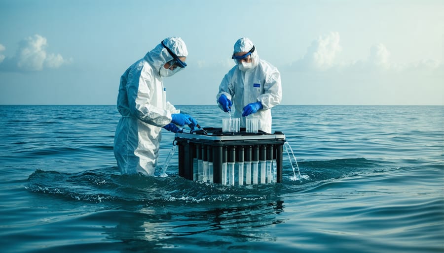
eDNA Sampling
Environmental DNA (eDNA) analysis represents a groundbreaking approach to marine species monitoring and biodiversity assessment. By collecting and analyzing genetic material naturally shed by organisms into the water, scientists can identify the presence of various marine species without direct observation or capture. This revolutionary method involves filtering seawater samples to capture tiny fragments of DNA from scales, waste, and other cellular material.
The process has transformed how we study marine ecosystems, enabling researchers to detect rare species, track invasive organisms, and monitor population changes with unprecedented accuracy. A single water sample can reveal the presence of hundreds of species, from microscopic plankton to large marine mammals, making it particularly valuable for conservation efforts.
Marine biologists are increasingly incorporating eDNA sampling into their research toolkits, combining it with traditional survey methods for more comprehensive ecosystem assessments. The technique has proven especially useful in deep-sea environments and remote locations where direct observation is challenging. Recent advances in DNA sequencing technology have made the process more efficient and cost-effective, opening new possibilities for citizen science initiatives and community-based monitoring programs.
Genetic Mapping for Conservation
Genetic mapping has emerged as a powerful tool in marine conservation, allowing scientists to track and protect endangered species with unprecedented precision. By analyzing DNA samples collected from marine organisms, researchers can identify distinct populations, map migration patterns, and assess genetic diversity within species.
Marine biologists use advanced sequencing techniques to create detailed genetic profiles of various marine species, from whales to coral populations. This data helps conservationists understand population connectivity, identify breeding grounds, and develop more effective protection strategies. For example, genetic mapping has revealed previously unknown breeding sites for endangered sea turtles and helped establish protected marine corridors.
The technology also enables scientists to monitor the health of marine populations by measuring genetic diversity, which is crucial for species’ resilience to environmental changes. By identifying genetically unique populations, conservation efforts can be prioritized to protect the most vulnerable groups.
Volunteer citizen scientists often contribute to these efforts by collecting DNA samples during beach walks or diving expeditions, making genetic mapping a collaborative endeavor between researchers and the public. This approach has revolutionized our understanding of marine ecosystems and strengthened conservation strategies worldwide.
Data Analytics and AI in Ocean Conservation
Predictive Modeling
Artificial Intelligence and machine learning have revolutionized our ability to predict and understand marine ecosystem changes. Advanced predictive modeling systems now process vast amounts of oceanographic data, including temperature variations, current patterns, and chemical compositions, to forecast potential changes in marine environments with unprecedented accuracy.
These AI-powered models integrate data from various sources, including satellite imagery, underwater sensors, and historical records, to create comprehensive forecasts of ocean conditions. Marine scientists use these predictions to anticipate phenomena like coral bleaching events, harmful algal blooms, and changes in species distribution patterns weeks or even months in advance.
For example, the latest neural network models can predict sea surface temperature anomalies with 85% accuracy up to six months ahead, enabling better preparation for marine heat waves. These systems also help track and predict the movement of endangered species, allowing conservation efforts to be more targeted and effective.
Citizen scientists and volunteer observers contribute valuable data to these models through mobile apps and online platforms, making predictive modeling a collaborative effort between technology and human observation. This combination of artificial and human intelligence has become instrumental in developing proactive conservation strategies and understanding the complex dynamics of our changing oceans.
Machine Learning for Species Protection
Machine learning and artificial intelligence are revolutionizing marine species protection efforts worldwide. Advanced algorithms can now process vast amounts of underwater camera footage and acoustic data in hours rather than months, dramatically improving our ability to monitor and protect vulnerable marine species.
These AI systems excel at identifying and tracking marine mammals, sea turtles, and endangered fish species through pattern recognition and behavioral analysis. For instance, researchers at the Woods Hole Oceanographic Institution have developed neural networks that can distinguish between different whale species with 95% accuracy using their distinctive vocalizations.
The technology is particularly valuable in combating illegal fishing. AI-powered drones and satellite systems can identify suspicious vessel behavior and alert authorities to potential poaching activities in protected areas. These systems operate continuously, providing round-the-clock surveillance that would be impossible with human observers alone.
Citizen scientists are also contributing to these efforts through mobile apps that use machine learning to help identify and report marine species sightings. This collaborative approach has created extensive databases that help researchers track population changes and migration patterns, leading to more effective conservation strategies.
Recent developments in deep learning have enabled real-time species monitoring, allowing for immediate response to threats and better understanding of ecosystem dynamics.
Future Horizons in Marine Tech
The future of oceanographic technology promises groundbreaking innovations that could revolutionize our approach to protecting ocean ecosystems. Advanced artificial intelligence systems are being developed to process vast amounts of marine data in real-time, enabling faster responses to environmental threats and more accurate predictions of ocean patterns.
Emerging biotechnology applications include DNA-based sensors that can detect microscopic changes in marine environments, providing early warnings of harmful algal blooms or invasive species. These sensors, coupled with autonomous underwater vehicles, create a network of smart monitoring systems that operate continuously without human intervention.
Quantum computing applications are showing promise in modeling complex ocean systems, potentially transforming our understanding of marine ecosystem dynamics. Scientists are also exploring biodegradable materials for ocean monitoring devices, ensuring that our conservation tools don’t contribute to marine pollution.
Perhaps most exciting is the development of swarm robotics – groups of small, interconnected robots that work together to monitor vast ocean areas. These swarms could track marine migration patterns, measure pollution levels, and document previously unseen deep-sea phenomena.
The integration of satellite technology with underwater communications is creating seamless data networks, allowing researchers to share discoveries and coordinate conservation efforts globally. As these technologies mature, they’re becoming more accessible to smaller research organizations and citizen scientists, democratizing marine conservation efforts.
jessica
Ava Singh is an environmental writer and marine sustainability advocate with a deep commitment to protecting the world's oceans and coastal communities. With a background in environmental policy and a passion for storytelling, Ava brings complex topics to life through clear, engaging content that educates and empowers readers. At the Marine Biodiversity & Sustainability Learning Center, Ava focuses on sharing impactful stories about community engagement, policy innovations, and conservation strategies. Her writing bridges the gap between science and the public, encouraging people to take part in preserving marine biodiversity. When she’s not writing, Ava collaborates with local initiatives to promote eco-conscious living and sustainable development, ensuring her work makes a difference both on the page and in the real world.