Marine Biodiversity Science Center
Monitoring Changes in the Coastline Using Satellite Images
Coastlines are among the most dynamic environments on Earth, constantly reshaped by storms, tides, and human activity. About 80% of the world’s coasts are changing at rates ranging from 1 cm per year to 10 m per year. Tracking these changes is essential for protecting communities and ecosystems, yet traditional field surveys are costly and limited in scope.
Recent advances in Earth observation allow researchers to process massive datasets quickly, providing accurate shoreline monitoring at local, regional, and global scales. Using current satellite images, scientists can detect erosion, accretion, and bathymetric changes with remarkable precision. Current satellite imagery of Earth is available for specialists of any scale today. With the help of easy-to-use digital platforms, you can get real-time satellite images of your AOI in two clicks. This progress offers practical tools for coastal management, environmental protection, and long-term adaptation to climate-driven challenges such as sea-level rise and intensified storms.
Why Coastline Monitoring Matters
The world’s coastlines sustain ecosystems and their biodiversity, being a home to nearly 40% of the global population, according to the United Nations UNEP. Unfortunately, even small shifts in the shoreline can affect both natural habitats and human livelihoods. That’s why this topical challenge needs to be monitored continuously and solved. By using current satellite imagery, scientists and conservationists gain accurate and up-to-date data that allows to react in a timely manner in four critical areas:
- Environmental protection: Live satellite view allows for detecting erosion and habitat losses early, safeguarding mangroves, wetlands, and coral reefs.
- Disaster management: With timely satellite monitoring, specialists can highlight areas most at risk from flooding, storm surges, and tsunamis, allowing early response.
- Urban planning: Reliable data ensures sustainable infrastructure development, particularly in rapidly growing coastal cities.
- Climate adaptation: Tracking sea-level rise over decades provides the evidence needed for governments and communities to build resilience.
Understanding the Basics of Coastal Erosion Mapping
Coastal erosion mapping is the process of measuring and visualizing how shorelines change over time under the influence of natural factors and human activities. For instance, in the UK, coastal risk management authorities and the Environment Agency created the National Coastal Erosion Risk Map (NCERM) that shows projected areas at risk from erosion. And they widely use satellite programs like Sentinel 2- and Landsat. So, instead of measuring the beach with only field surveys, scientists now use satellite data and remote sensing to map these changes more efficiently. And what is the process? It consists of several stages:
- Observation: Satellites take repeated images of the same coastal area.
- Analysis: Specialized software identifies the “waterline” (where land meets the sea) in each image.
- Comparison: By comparing images over weeks, months, or years, scientists see whether beaches are eroding, stable, or gaining sand.
Key Factors Affecting Shoreline Changes
The results of various research indicate that the majority of shoreline accretion is a consequence of human activities, which are associated with the high economic activity over the past two decades. But nevertheless, shoreline change is shaped by natural forces as well. Understanding these drivers is essential for accurate monitoring and effective coastal management.
Natural factors include:
- Wave energy and tidal patterns: Strong, powerful waves erode beaches quickly, while the dominant wave direction gradually shapes the overall layout of the shoreline.
- Sediment supply and transport: Beaches need a regular flow of sand and sediment to stay stable. When this supply is interrupted, the shoreline starts to shrink.
- Geological composition: The material of the coast plays a big role. Sandy or clay-rich coasts erode much faster than rocky ones, which hold their shape against waves.
- Storm frequency and intensity: Powerful storms can erase large sections of coastline in a short time, as storm surges and pounding waves strip away sand and soil.
Human activities further intensify these processes:
- Coastal construction and hardening (e.g., seawalls) alter natural sediment flow.
- Sand mining and dredging remove material vital for beach stability.
- Port and harbor development reshapes tidal flows and currents.
- Beach nourishment projects temporarily restore sand but require repeated intervention.
Practical Applications of Coastal Monitoring
Satellite imagery is not just a research and observation tool but a practical remote sensing instrument that plays a direct role in protecting lives and infrastructure worldwide. By analyzing this data, governments and organizations around the globe can better prepare for environmental risks on coasts and beyond.
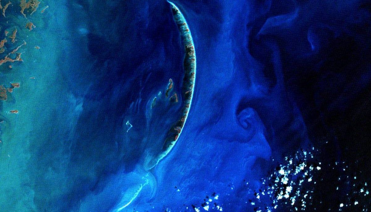
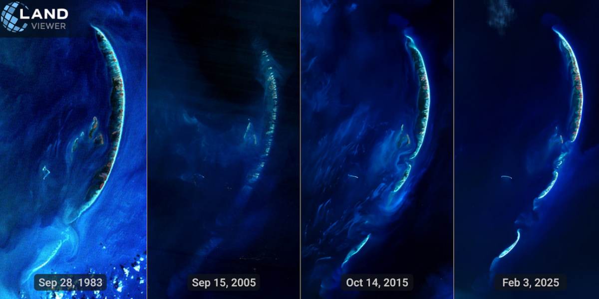
- The Chandeleur Islands, located off the coast of Louisiana, clearly demonstrate how barrier islands transform over time. The time series of satellite images (1983–2025) shows significant morphological changes: breaches, fragmentation, and shoreline retreat. After Hurricane Katrina in 2005, the islands suffered dramatic erosion—large portions were destroyed or reshaped, and even the historic Chandeleur lighthouse was lost. Subsequent images highlight continued instability of this fragile ecosystem, with land loss accelerating in recent decades.
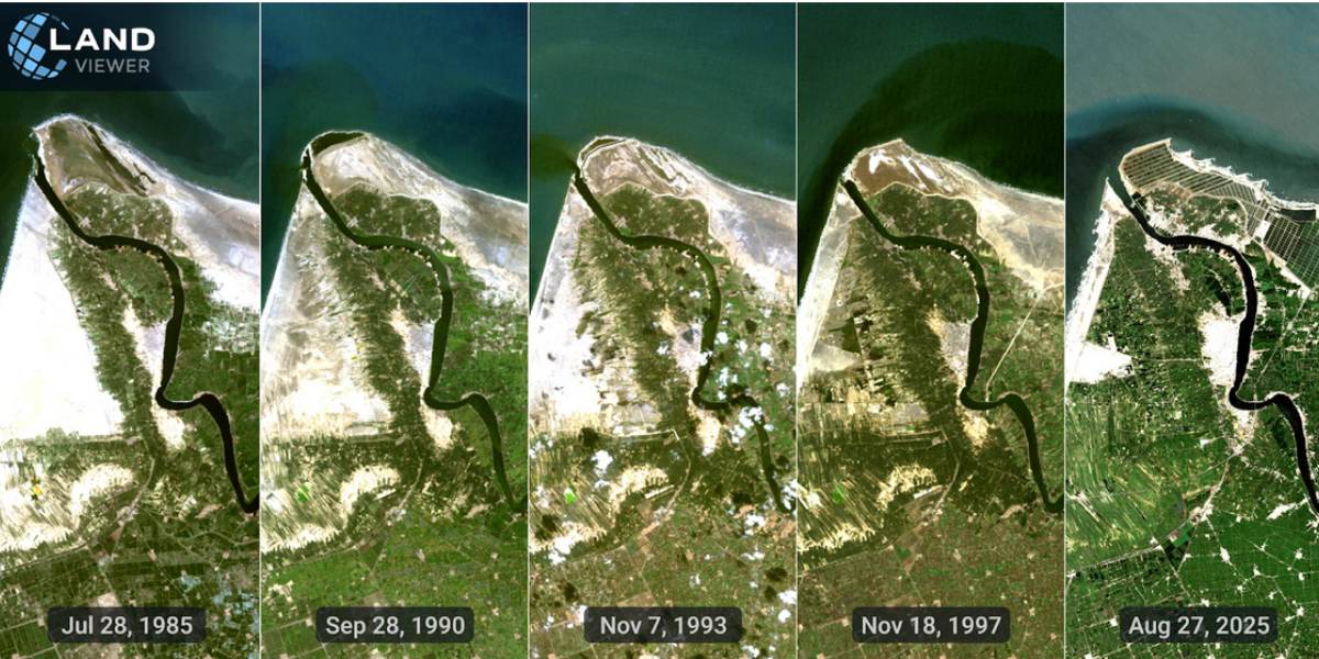
- Nile Delta (Rosetta Promontory), Egypt. Event: After the construction of the Aswan High Dam in 1970, sediment flow to the Mediterranean was cut off, causing the shoreline to retreat several kilometers inland. Villages and farmland gradually disappeared in a process of “slow destruction,” as the entire promontory was eroded away. Time-series Landsat images (1985–2025) clearly illustrate this dramatic change. Once a prominent feature, the promontory has been steadily consumed by wave action, storm surges, and rising sea levels, leaving communities, agricultural land, and infrastructure submerged or permanently lost. Entire settlements have been forced to relocate as fertile fields vanished beneath advancing waters.
Strengthening Coastal Resilience with Risk Assessments
Effective shoreline management and risk assessment require more than observation. Scientists and policymakers follow the simple plan:
- Firstly, they analyze historical erosion trends.
- Secondly, based on those trends they identify vulnerable coastal zones with the help of up-to-date platforms and AI algorithms.
- Thirdly, scientist combine erosion rates with storm surge models and create hazard maps.
- Finally, they can safely invest in resilient infrastructure, plan evacuation, and build emergency response strategy.
Challenges and the Road Ahead
Although coastal research has undergone significant improvements over the last decade, it still faces several challenges. Erosion trends can be difficult to detect due to seasonal fluctuations, making it difficult to separate natural cycles from structural shoreline changes. This challenge is likely to be addressed as newer Landsat satellites with higher-resolution sensors come online, allowing us to see smaller, more detailed changes along the coast, information that is crucial for local planning. Processing these large amounts of data still requires powerful computers and specialized skills, but as technology continues to advance, these hurdles are expected to become much easier to manage.
jessica
Ava Singh is an environmental writer and marine sustainability advocate with a deep commitment to protecting the world's oceans and coastal communities. With a background in environmental policy and a passion for storytelling, Ava brings complex topics to life through clear, engaging content that educates and empowers readers. At the Marine Biodiversity & Sustainability Learning Center, Ava focuses on sharing impactful stories about community engagement, policy innovations, and conservation strategies. Her writing bridges the gap between science and the public, encouraging people to take part in preserving marine biodiversity. When she’s not writing, Ava collaborates with local initiatives to promote eco-conscious living and sustainable development, ensuring her work makes a difference both on the page and in the real world.